Kugluktuk, Nunavut
|
Kugluktuk Qurluqtuq ᖁᕐᓗᖅᑐᖅ |
|
|---|---|
| Hamlet | |

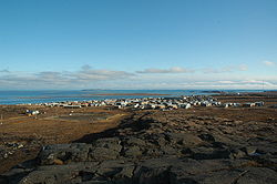
Hill top view of Kugluktuk
|
|
| Coordinates: 67°49′32″N 115°05′42″W / 67.82556°N 115.09500°WCoordinates: 67°49′32″N 115°05′42″W / 67.82556°N 115.09500°W | |
| Country | Canada |
| Territory | Nunavut |
| Region | Kitikmeot Region |
| Electoral district | Kugluktuk |
| Government | |
| • Mayor | Ryan Nivingalok |
| • MLA | Peter Taptuna |
| Area | |
| • Land | 549.65 km2 (212.22 sq mi) |
| • Population centre | 0.34 km2 (0.13 sq mi) |
| Elevation | 23 m (75 ft) |
| Population (2016) | |
| • Total | 1,491 |
| • Density | 2.6/km2 (7/sq mi) |
| • Population centre | 1,057 |
| • Population centre density | 3,148.6/km2 (8,155/sq mi) |
| Time zone | MST (UTC-7) |
| • Summer (DST) | MDT (UTC-6) |
| Canadian Postal code | X0B 0E0 |
| Area code(s) | 867 |
Kugluktuk (Inuinnaqtun: Qurluktuk, "the place of moving water"; Inuktitut: ᖁᕐᓗᖅᑐᖅ, formerly Coppermine until 1 January 1996) is a hamlet located at the mouth of the Coppermine River in the Kitikmeot Region of Nunavut, Canada, on Coronation Gulf, southwest of Victoria Island. It is the westernmost community in Nunavut, near the border with the Northwest Territories.
The traditional language of the area is Inuinnaqtun and is written using the Latin alphabet, rather than the syllabics of the Inuktitut writing system. Like Cambridge Bay, Bathurst Inlet, and Umingmaktok, syllabics are rarely seen and are used mainly by the Government of Nunavut.
The community has the usual services: a post office, Northern Store, co-op store, and Hunters & Trappers Association. The two schools in the area are Kugluktuk High School and Jimmy Hikok Ilihakvik. In June 2004, a fuel line broke in the center of Kugluktuk, spilling 2,000 L (439.9 imp gal; 528.3 US gal) of diesel fuel.
At the 2016 census, the population was 1,491, an increase of 2.8% from the 2011 census. The Population centre showed a population of 1,057, in an area of 0.34 km2 (0.13 sq mi), an increase of 1% from 2011.
...
Wikipedia

