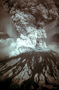
1980 eruption of Mount St. Helens
| 1980 eruption of Mt. St. Helens | |
|---|---|

Photograph of the eruption column, May 18, 1980.
|
|
| Volcano | Mount St. Helens |
| Date | May 18, 1980 |
| Time | 8:32 am PDT |
| Type | Plinian, Peléan |
| Location |
Skamania County, Washington 46°12′1″N 122°11′12″W / 46.20028°N 122.18667°W |
| VEI | 5 |
| Impact | Approximately 57 deaths, about $1.1 billion in property damage; caused a partial collapse of the volcano's flank, deposited ash in eleven states and five Canadian provinces |

Map of eruption deposits
|
|
On May 18, 1980, a major volcanic eruption occurred at Mount St. Helens, a volcano located in the state of Washington, United States. The eruption (a VEI 5 event) was the only significant volcanic eruption to occur in the contiguous 48 U.S. states since the 1915 eruption of Lassen Peak in California. However, it has often been declared as the most disastrous volcanic eruption in United States history. The eruption was preceded by a two-month series of earthquakes and steam-venting episodes, caused by an injection of magma at shallow depth below the volcano that created a huge bulge and a fracture system on the mountain's north slope.
An earthquake at 8:32:17 a.m. PDT (UTC−7) on Sunday, May 18, 1980, caused the entire weakened north face to slide away, creating the largest landslide ever recorded. This suddenly exposed the partly molten gas- and steam-rich rock in the volcano to lower pressures. The rock responded by exploding a hot mix of lava and pulverized older rock toward Spirit Lake so fast that it overtook the avalanching north face.
An eruption column rose 80,000 feet (24 km; 15 mi) into the atmosphere and deposited ash in 11 U.S. states. At the same time, snow, ice and several entire glaciers on the volcano melted, forming a series of large lahars (volcanic mudslides) that reached as far as the Columbia River, nearly 50 miles (80 km) to the southwest. Less severe outbursts continued into the next day, only to be followed by other large, but not as destructive, eruptions later that year.
...
Wikipedia
