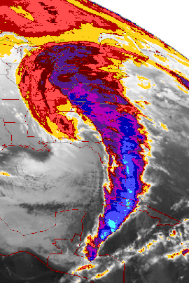
1993 Storm of the Century
| Category 5 "Extreme" (RSI: 24.433) | |

|
|
| Type | Superstorm Extratropical cyclone Nor'easter Blizzard |
|---|---|
| Formed | March 12, 1993 |
| Dissipated | March 15, 1993 |
| Lowest pressure | 960 mb (hPa) |
| Lowest temperature | −12 °F (−24 °C) |
| Maximum snowfall or ice accretion | 69 in (180 cm) – Mt. Le Conte, TN |
| Damage | $8.7 billion (2013 US$) |
| Casualties | 318 fatalities |
| Areas affected | Canada, United States, and Cuba |
|
Snowstorm Totals Totals are for the main system only. |
|
|---|---|
| Snowshoe, WV | 44 in (110 cm) |
| Syracuse, NY | 43 in (110 cm) |
| Tobyhanna, PA | 42 in (110 cm) |
| Lincoln, NH | 35 in (89 cm) |
| Boone, NC | 33 in (84 cm) |
| Gatlinburg, TN | 30 in (76 cm) |
| Pittsburgh, PA | 25.2 in (64 cm) |
| Chattanooga, TN | 23 in (58 cm) |
| London, KY | 22 in (56 cm) |
| Worcester, MA | 20.1 in (51 cm) |
| Ottawa, ON | 17.7 in (45 cm) |
| Birmingham, AL | 13 in (33 cm) |
| Montreal, QC | 16.1 in (41 cm) |
| Trenton, NJ | 14.8 in (38 cm) |
| Washington, D.C. (Dulles) | 14.1 in (36 cm) |
| Birmingham, AL | 13 in (33 cm) |
| Boston, MA | 12.8 in (33 cm) |
| New York, NY (LaGuardia) | 12.3 in (31 cm) |
| Baltimore, MD (BWI) | 11.9 in (30 cm) |
| Atlanta, GA (northern suburbs) | 10.0 in (25 cm) |
| Huntsville, AL | 7 in (18 cm) |
| Washington, D.C. (National Airport) | 6.6 in (17 cm) |
| Atlanta, GA (Hartsfield-Jackson International Airport) | 4.5 in (11 cm) |
| Mobile, AL | 3 in (7.6 cm) |
The 1993 Storm of the Century, also known as the '93 Super Storm, the Great Blizzard of 1993, or the No Name Storm, was a large cyclonic storm that formed over the Gulf of Mexico on March 12, 1993. The storm eventually dissipated in the North Atlantic Ocean on March 15, 1993. It was unique for its intensity, massive size, and wide-reaching effects, particularly in the southeastern United States. At its height, the storm stretched from Canada to Central America, but it impacted mainly the eastern United States and Cuba. The cyclone moved through the Gulf of Mexico and then through the eastern United States before moving onto Canada.
Areas as far south as central Alabama and Georgia received 7 to 8 inches (18 to 20 cm) of snow. Areas such as Birmingham, Alabama, received up to 13 inches (33 cm) with isolated reports of 16 inches (41 cm). The Florida Panhandle reported up to 4 inches (10 cm), with hurricane-force wind gusts and record low barometric pressures. Between Louisiana and Cuba, the hurricane-force winds produced high storm surges across Northwestern Florida which, in combination with scattered tornadoes, killed dozens of people.
Record cold temperatures were seen across portions of the south and east of the US in the wake of this storm. In the United States, the storm was responsible for the loss of electric power to more than 10 million households. An estimated 40 percent of the country's population experienced the effects of the storm with a total of 208 fatalities, making it one of the deadliest weather events of the 20th century.
The 1993 Storm of the Century marked a milestone in the weather forecasting of the United States. By March 8, 1993, several operational numerical weather prediction models and medium-range forecasters at the United States National Weather Service recognized the threat of a significant snowstorm. This marked the first time National Weather Service meteorologists were able to predict accurately a system's severity five days in advance. Official blizzard warnings were issued two days before the storm arrived, as shorter-range models began to confirm the predictions. Forecasters were finally confident enough of the computer-forecast models to support decisions by several northeastern states to declare a State of Emergency even before the snow started to fall.
...
Wikipedia
