Aquidneck Island

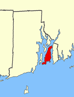
Aquidneck Island highlighted in red
|
|
| Geography | |
|---|---|
| Location | Narragansett Bay |
| Coordinates | 41°33′20″N 71°15′53″W / 41.55556°N 71.26472°W |
| Area | 37.8 sq mi (98 km2) |
| Length | 15 mi (24 km) |
| Width | 5 mi (8 km) |
| Highest elevation | 260 ft (79 m) |
| Highest point | Slate Hill |
| Administration | |
|
United States
|
|
| State | Rhode Island |
| County | Newport County |
| Largest settlement | Newport (pop. 24,672) |
| Demographics | |
| Population | 58,211 (2010) |
| Pop. density | 621.12 /km2 (1,608.69 /sq mi) |
Aquidneck Island, officially Rhode Island, is located in Narragansett Bay in the U.S. state of Rhode Island. The total land area is 97.9 km2 (37.8 sq mi), which makes it the largest island in the bay. The 2000 United States Census reported its population as 60,870.
Aquidneck Island is home to three towns, from north to south geographically: Portsmouth, Middletown, and Newport.
"Aquidneck" is derived from the Narragansett name for the island aquidnet. The word literally means "floating-mass-at" or simply "at the island". Other sources claim that Aquidneck is an Indian word meaning "Isle of Peace."
It is unclear how Aquidneck Island came to be known as Rhode Island. In 1524, explorer Giovanni da Verrazzano noted the presence of an island near the mouth of Narragansett Bay which he likened to the Greek island of Rhodes. It is uncertain to which island he was referring, but the Pilgrims who later colonized the area decided to refer to Aquidneck as Rhode Island. The earliest known use of the name Rode Island was in 1637 by Roger Williams. The name was officially applied to the island in 1644 with these words: "Aquethneck shall be henceforth called the Ile of Rods or Rhod-Island." The name "Isle of Rodes" is found used in a legal document as late as 1646.
Another popular origin theory is based on the fact that Adriaen Block passed by Aquidneck Island during his 1614 expedition, described in a 1625 account of his travels as "an island of reddish appearance" (in 17th century Dutch een rodlich Eylande). Dutch maps from as early as 1659 call it "Roode Eylant" or Red Island. Historians have theorized that it was named by the Dutch (possibly by Adriaen Block himself) for either the red autumn foliage or red clay on portions of the shore.
In 1644, the colonies of Rhode Island and Providence Plantation combined to form the Colony of Rhode Island and Providence Plantations, and eventually the State of Rhode Island and Providence Plantations. The entire state is now commonly referred to as Rhode Island, even though the official name of Aquidneck Island is still "Rhode Island." The U.S. Board on Geographic Names addressed the issue in 1930 by using both names of the island on its maps. By 1964, the board decided that having two names was confusing, and "Rhode Island" was used exclusively as the official name of the island. Attempts to change the official name to "Aquidneck Island" have been made as recently as 2004, but all of these have failed. A compromise was reached in 2011 when the RI State Department of Transportation allowed "Aquidneck Island" to be added to state maps as a variant appellation. This variant was employed as a result of the 2006 decision by the U.S. Board of Geographic Names to allow "Rhode Island" and "Aquidneck Island" to co-exist on nautical maps.
...
Wikipedia

