Ash Vale
| Ash Vale | |
|---|---|
 The Basingstoke Canal Aqueduct/Viaduct over the Blackwater has an adjoining footpath lined with mature gorse and heather, endemic to the south and east of the area. |
|
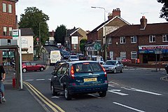
 Local shops at a busy crossroads, near Ash Wharf on the canal. The village is part of the technology-focussed Blackwater Valley Conurbation. |
|
| Ash Vale shown within Surrey | |
| Area | 3.62 km2 (1.40 sq mi) |
| Population | 5,686 (2011 census) |
| • Density | 1,571/km2 (4,070/sq mi) |
| OS grid reference | SU891524 |
| Civil parish | |
| District | |
| Shire county | |
| Region | |
| Country | England |
| Sovereign state | United Kingdom |
| Post town | Aldershot |
| Postcode district | GU12 |
| Dialling code | 01252 |
| Police | Surrey |
| Fire | Surrey |
| Ambulance | South East Coast |
| EU Parliament | South East England |
| UK Parliament | |
Ash Vale is a village in the borough of Guildford in Surrey, England and the larger, northern settlement of the civil parish of Ash. It is 7 miles (11 km) from Guildford but is closer to the Hampshire towns of Aldershot and Farnborough, the centres of which are each about two miles (4 km) away, immediately across the two crossings of the River Blackwater, to the southwest and northwest.
Ash Vale's extent is on two sides clearly demarcated, by the river to the west and at a few locks' higher elevation by the parallel Basingstoke Canal to the east – across these boundaries are, respectively, Aldershot Garrison (Military Town) and the large Surrey Heath MoD, mostly UK Army, ranges and training areas. The latter is a co-managed County Wildlife Site, for instance Ash Ranges at 2,439 acres (987 ha) and Pirbright Ranges at 2,765 acres (1,119 ha), with various access days and parts (see the Wildlife's Trust website). The type of soil of the east, the heath is very acidic, sandy and loamy which makes up just 1.9% of English soil and 0.2% of Welsh soil, which gives rise to pines and coniferous landscapes, such as pioneered at Wentworth and Foxhills estate and is good for biodiversity.
Two branch railway lines cross in the middle of the village without forming a junction. In the north of the village are Ash Vale railway station and North Camp railway station, on the London-Aldershot-Alton Line and the Reading-Guildford-Gatwick Line respectively. In addition, trains run through Ash Vale from Guildford to Ascot via Aldershot. The village owes its development to the Garrison and to the railways; see the description of the often heath soil under the Ash article, explaining how to the south lies a limited area of fertile farming country.
...
Wikipedia

