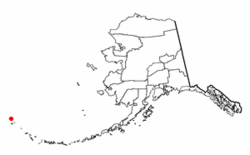
Attu Station
| Attu Station, Alaska | |
|---|---|
| CDP | |

Attu Island with land area of 892.795 km² (344.71 sq mi)
|
|
 Location of Attu Station, Alaska |
|
| Coordinates: 52°50′47″N 173°11′10″E / 52.84639°N 173.18611°E | |
| Country | United States |
| State | Alaska |
| Census Area | Aleutians West |
| Government | |
| • State senator | Lyman Hoffman (D) |
| • State rep. | Bryce Edgmon (D) |
| Area | |
| • Total | 143.6 sq mi (372.1 km2) |
| • Land | 142.6 sq mi (369.3 km2) |
| • Water | 1.1 sq mi (2.8 km2) |
| Population (2010) | |
| • Total | 0 |
| Time zone | Hawaii-Aleutian (HST) (UTC-10) |
| • Summer (DST) | HDT (UTC-9) |
| Area code(s) | 907 |
| FIPS code | 02-04670 |
Attu Station is a census-designated place (CDP) located on Attu Island in the Aleutians West Census Area in the U.S. state of Alaska. The population was 21 at the 2010 census, consisting entirely of coast guard personnel who resided and worked at Casco Cove Coast Guard Station, but left the island when the station was closed in August 2010, leaving it uninhabited. LORAN Station Attu had provided a navigational signal for mariners of the North Pacific since the 1970s.
Although often considered the westernmost place in the United States due to its location relative to the rest of the country, Attu Station is actually one of the easternmost points in the United States, located at 52°50′47″N 173°11′10″E / 52.84639°N 173.18611°ECoordinates: 52°50′47″N 173°11′10″E / 52.84639°N 173.18611°E, on the opposite side of the 180th meridian from the rest of the United States. (See Extreme Points.)
...
Wikipedia
