Barnstable County, Massachusetts
| Barnstable County, Massachusetts | ||
|---|---|---|

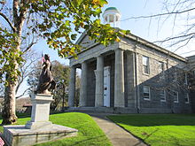
Barnstable County Courthouse
|
||
|
||
 Location in the U.S. state of Massachusetts |
||
 Massachusetts's location in the U.S. |
||
| Founded | 1685 | |
| Seat | Barnstable | |
| Largest city | Barnstable | |
| Area | ||
| • Total | 1,306 sq mi (3,383 km2) | |
| • Land | 394 sq mi (1,020 km2) | |
| • Water | 912 sq mi (2,362 km2), 70% | |
| Population (est.) | ||
| • (2015) | 214,333 | |
| • Density | 544/sq mi (210/km²) | |
| Congressional district | 9th | |
| Time zone | Eastern: UTC-5/-4 | |
| Website | www |
|
Barnstable County is a county located in the U.S. state of Massachusetts. As of the 2010 census, the population was 215,888. Its county seat is Barnstable. The county consists of Cape Cod and associated islands (some adjacent islands are in Dukes County and Nantucket County).
Barnstable County comprises the Barnstable Town, MA Metropolitan Statistical Area, which is also included in the Boston-Worcester-Providence, MA-RI-NH-CT Combined Statistical Area.
Barnstable County was formed as part of the Plymouth Colony on 2 June 1685, including the towns of Falmouth, Sandwich and others lying to the east and north on Cape Cod. Plymouth Colony was merged into the Province of Massachusetts Bay in 1691.
Cape Cod is described in a letter from the Italian explorer Giovanni da Verrazzano to Francis I of France, relating the details of a voyage to the New World made on behalf of the French crown in the ship Dauphine, the only surviving of a fleet of four. Sailing from Madeira in 1524, the Dauphine made land in North Carolina in March. It sailed north to Newfoundland, mapping the coast and interviewing the natives, whom he found friendly south of the cape, but unfriendly north of it. To the north of an island that reminded Verrazzano of Rhodes, the Dauphine made its way with difficulty over shoals "never less than three feet deep" extending "from the continent fifty leagues out to sea," which Brevoort, based on their extent, has identified as Nantucket Shoals. Verrazzano called them Armellini. On the other side was a promontory, Pallavisino, which is probably the cape, as they sailed along it for "fifty leagues." Details of the north end are not given, but subsequently they came to a "high country, full of very dense forests, composed of pines," which, according to Brevoort and others, resembles the coast of Maine.
...
Wikipedia

