Belasitsa
| Belasica | |
|---|---|
| Bulgarian and Macedonian: Беласица - Greek: Μπέλλες or Κερκίνη | |

The linear ridge of Belasica, with Lake Dojran on the left
|
|
| Highest point | |
| Peak | Radomir Peak |
| Elevation | 2,029 m (6,657 ft) |
| Geography | |
| Countries | Bulgaria, Greece and Republic of Macedonia |
| Range coordinates | 41°20′N 22°57′E / 41.33°N 22.95°ECoordinates: 41°20′N 22°57′E / 41.33°N 22.95°E |
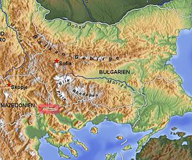
Belasica (Macedonian and Bulgarian: ![]() Беласица , also translit. Belasitsa or Belasitza, Ottoman Turkish:بلش Turkish Beleş), Belles (Greek: Μπέλλες/Bélles) or Kerkini (Κερκίνη/Kerkíni), is a mountain range in the region of Macedonia in Southeastern Europe, shared by northwestern Greece (about 45%), southeastern Republic of Macedonia (35%) and southwestern Bulgaria (20%).
Беласица , also translit. Belasitsa or Belasitza, Ottoman Turkish:بلش Turkish Beleş), Belles (Greek: Μπέλλες/Bélles) or Kerkini (Κερκίνη/Kerkíni), is a mountain range in the region of Macedonia in Southeastern Europe, shared by northwestern Greece (about 45%), southeastern Republic of Macedonia (35%) and southwestern Bulgaria (20%).
The mountain range is about 60 km (37.28 mi) long and 7 to 9 km (4.35 to 5.59 mi) wide and is situated just northeast of Dojran Lake. The highest point is Radomir (Kalabak) at 2,029 m, with elevation otherwise ranging between 300 and 1900 m above sea level. The borders of all three countries meet at Tumba Peak. The climate in the area shows strong Mediterranean influence.
The area of Belasica became a euroregion in 2003. Two football teams are named after the mountain range, PFC Belasitsa from the nearby Bulgarian town of Petrich and FC Belasica from Strumica in the Republic of Macedonia.
...
Wikipedia

