Blue Lake (South Australia)
| Blue Lake | |
|---|---|

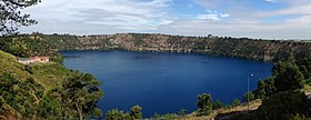
Panorama of the Blue Lake in late-December.
|
|
|
Location in South Australia
|
|
| Location | Mount Gambier, South Australia |
| Coordinates | 37°50′48″S 140°46′41″E / 37.84667°S 140.77806°ECoordinates: 37°50′48″S 140°46′41″E / 37.84667°S 140.77806°E |
| Type | Monomictic crater lake |
| Basin countries | Australia |
| Max. length | 1,087 m (3,566 ft) |
| Max. width | 657 m (2,156 ft) |
| Surface area | 70 ha (170 acres) |
| Average depth | 72 m (236 ft) |
| Max. depth | 77 m (253 ft) |
| Water volume | none |
| Residence time | 3.45 years |
| Shore length1 | None |
| Surface elevation | approx. 20 m (66 ft) |
| Islands | None |
| Settlements | None |
| 1 Shore length is not a well-defined measure. | |
The Blue Lake is a large monomictic crater lake located in a dormant volcanic maar associated with the Mount Gambier maar complex. The lake is situated near Mount Gambier in the Limestone Coast region of South Australia and is one of four crater lakes on Mount Gambier maar. Of the four lakes, only two remain, as the other two (Leg of Mutton and Brown) have dried up over the past 30 to 40 years as the water table has dropped.
Conflicting dates have been estimated for its last eruption, of 4,300 years ago, of 28,000 years ago, and, most recently, a little before 6,000 years ago. If the youngest date is correct, this could be the most recent volcanic eruption on the Australian mainland.
Blue Lake is thought to be of an average depth of 72 metres (236 ft), but in places reaches 75 metres (246 ft) deep. The crater rim measures 1,200 metres (3,900 ft) by 824 metres (2,703 ft), however, the lake itself measures 1,087 metres (3,566 ft) by 657 metres (2,156 ft). The bottom of the lake is 30 metres (98 ft) below the level of the main street of the nearby town. The Blue Lake supplies the town with drinking water, providing approximately 3,500 megalitres (920,000×103 US gal; 770,000×103 imp gal) per year from its 36,000 ML (9,500,000×103 US gal; 7,900,000×103 imp gal) store.
Bathymetric surveys located the deepest point in the lake at 77 metres (253 ft) in 1967. Major diving exploration of the lake first occurred in 1985. Cave diver Peter Horne conducted temperature and visibility studies and made discoveries of a fresh water sponge species and other invertebrates. This exploration also discovered "The Stromatolite Field", a collection of hollow rock formations that are found along the north-eastern perimeter down to a depth of 40 metres (130 ft). In 2008, permission was granted by SA Water for another diving exploration of the central and deepest parts of the lake. On this dive core samples from the calcite-silt covered lake bed were collected where water temperature drops to 14 °C (57 °F).
...
Wikipedia

