Brimington
| Brimington | |
|---|---|
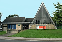
 Methodist Church at Brimington. |
|
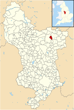
 Brimington parish highlighted within Derbyshire |
|
| Population | 8,788 (2011) |
| OS grid reference | SK406736 |
| Civil parish |
|
| District | |
| Shire county | |
| Ceremonial county | |
| Region | |
| Country | England |
| Sovereign state | United Kingdom |
| Post town | CHESTERFIELD |
| Postcode district | S43 |
| Dialling code | 01246 |
| Police | Derbyshire |
| Fire | Derbyshire |
| Ambulance | East Midlands |
| EU Parliament | East Midlands |
| UK Parliament | |
Coordinates: 53°15′29″N 1°23′26″W / 53.2580°N 1.3905°W
Brimington is a civil parish within the borough of Chesterfield in north-east Derbyshire, England. The population of the civil parish including Hollingwood taken at the 2011 Census was 8,788. The town of Staveley is to the east, and Hollingwood is nearby. The parish includes Brimington Common along the Calow Road, and New Brimington, a late 19th-century extension towards the Staveley Iron Works.
The Parish Council is the level of local government in Chesterfield nearest to the people of Brimington. The old parishes were formed at a time when there was little difference, to the local people, between the Church and the State. A parish like Brimington usually formed around a village or other small community and used to be centred on the Parish Church. In the late 1800s Church and State separated but the same area is now represented as a local authority by the Brimington Parish Council and the Church of England by the Parochial Church Council.
Brimington has two infant schools, Henry Bradley Infant School and Brimington Manor. Pupils generally feed into Brimington Junior School. Local secondary schools include Springwell Community College and Netherthorpe School.
Brimington has a small library, various businesses including a chemist, car garages and showrooms, shops and a petrol station.
...
Wikipedia
