Buckland, Gloucestershire
| Buckland | |
|---|---|
 The north wing of Buckland Manor, from the Churchyard. |
|
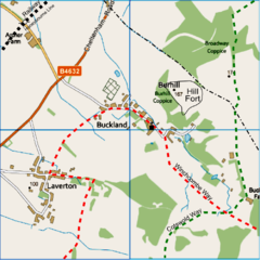
 Map of Buckland and Laverton |
|
| Buckland shown within Gloucestershire | |
| Population | 224 (including Laverton) 2010 estimate |
| OS grid reference | SP081361 |
| • London | 83 mi (134 km) |
| Civil parish |
|
| District | |
| Shire county | |
| Region | |
| Country | England |
| Sovereign state | United Kingdom |
| Postcode district | WR12 |
| Police | Gloucestershire |
| Fire | Gloucestershire |
| Ambulance | South Western |
| EU Parliament | South West England |
Buckland is a village and civil parish in the borough of Tewkesbury, Gloucestershire, England. The parish, which also includes the village of Laverton, had a population of 225 in 2010. The village is close to the Worcestershire border and 1.2 miles (2 km) south of Broadway. East of the village is the Burhill iron age hillfort. To the south, and within Buckland Parish, is the hamlet of Laverton. Within the village itself is the medieval Church of St Michael, a seventeenth-century manor house, and what claims to be the oldest Rectory in England.
Burhill hillfort occupies a spur on the Cotswold escarpment, overlooking Buckland and the Severn/Avon valley. Very little remains of any ramparts, except for a stretch on the eastern side, against the slope of the scarp, indicating an entranceway. The site was only identified as a hillfort in 1960. An area of some 3 hectares (7.4 acres) may have been enclosed, but on most sides the natural scarp is now the only remaining defensive feature. The whole area has been extensively ploughed, and within the hillfort a scatter of early to mid iron-age pottery has turned up. An area outside the fort, east of the entrance, has produced much greater quantities of pottery dating to the earliest period of the iron age, with many fragments of various jars and bowls.
The name 'Buckland' originates from Anglo-Saxon 'Boc-land', meaning land assigned under a charter, as distinct from the 'Folc-land' which bases its ownership on folk-testimony. The Charter in this case dates to 709AD, when Coenred of Mercia gave the land to St Peter's Abbey, Gloucester. The abbey had been founded 30 years before, and in 709 Coenred made this gift to the Church, gave up being King of the Mercians and went on pilgrimage to Rome, where he died. Buckland (which may be the manor described as Bibladene in the original charter), having come into the possession of Gloucester Abbey, remained so until the reformation, in around 1546. When the Normans took over, Abbot Serlo was put in charge of Gloucester Abbey, and under his stewardship Buckland, along with many of the Abbey's lands, increased in prosperity. By 1190 it had a church, although possibly this was at Laverton, within the parish, rather than in Buckland. The present Church,St Michael's, has fabric dating back to the 13th century, and its rectory dates in part to the 14th century.
...
Wikipedia

