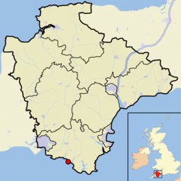
Burgh Island

View from Bigbury-on-Sea
|
|
| Geography | |
|---|---|
| Location | English Channel |
| Coordinates | 50°16′47″N 3°54′01″W / 50.27972°N 3.90028°WCoordinates: 50°16′47″N 3°54′01″W / 50.27972°N 3.90028°W |
| Administration | |
| Constituent country | England |
| Shire county | Devon |
| Shire district | South Hams |
| Additional information | |
| NB: Burgh Island is a tidal island | |
Burgh Island is a small tidal island on the coast of South Devon in England near the small seaside village of Bigbury-on-Sea. There are several buildings on the island, the largest being the Art Deco Burgh Island Hotel. The other buildings are three private houses, and a public house, the Pilchard Inn, run by the hotel.
Archaeological discovery of tin ingots at the River Erme estuary wreck such that the local area was a significant tin trading port in ancient times ; it is unclear whether the ingots date from the Iron Age or Sub-Roman periods, however this discovery so close to Burgh Island has drawn comparisons with Diodorus Siculus 1C BCE text, more often associated with St Michaels Mount in Cornwall:
At this time we shall treat of the tin which is dug from the ground. Those who dwell near Belerium, one of the headlands of Britain, are especially fond of strangers, and on account of their trade with the merchants they have a more civilized manner of living. They collect the tin after the earth has been skillfully forced to yield it. Although the land is stony, it has certain veins of earth from which they melt and purify the metal which has been extracted. After making this into bars they carry it to a certain island near Britain called Ictis. For although the place between is for the most part covered with water, yet in the middle there is dry ground, and over this they carry a great amount of tin in wagons [...] Thence the merchants carry into Gaul the tin which they have bought from the inhabitants. And after a journey of thirty days on foot through Gaul, they convey their packs carried by horses to the mouths of the Rhone River.
Though the early history of the island is unclear, however it is mentioned in early records and on maps as St Michael's Island. Later the name changed to Borough Island, eventually being corrupted to Burgh. As late as 1947 an Ordnance Survey map refers to the island as Borough Island. In 1908 a postcard produced by Stengel & Co Ltd of London referred to it as Burr Island. A map published in 1765 shows "Borough or Bur Isle".
...
Wikipedia

