Camberwell (parish)
| Camberwell | |
|---|---|
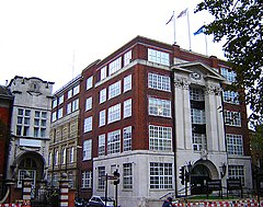
 The former Camberwell Town Hall (1934) |
|
 The Borough of Camberwell within the County of London |
|
| Area | |
| • 1911/1931 | 4,480 acres (18.1 km2) |
| • 1961 | 4,482 acres (18.14 km2) |
| Population | |
| • 1911 | 261,328 |
| • 1931 | 251,294 |
| • 1961 | 175,304 |
| Density | |
| • 1911 | 58/acre |
| • 1931 | 56/acre |
| • 1961 | 39/acre |
| History | |
| • Origin | Ancient parish |
| • Abolished | 1965 |
| • Succeeded by | London Borough of Southwark |
| Status |
Civil parish (until 1965) Metropolitan borough (1900–1965) |
| Government | Camberwell Vestry (1674–1900, reformed 1855) Camberwell Borough Council (1900–1965) |
| • HQ | St Giles's Church (1674–1827) Vestry Hall, Havil Street (1827–1873) Vestry Hall, Peckham Road (1873–1934) Town Hall, Peckham Road (1934–1965) |
| • Motto | All's well |
 Coat of arms of the borough council |
|
The Metropolitan Borough of Camberwell was a metropolitan borough in south London, England. Camberwell was an ancient parish in the county of Surrey, governed by an administrative vestry from 1674. The parish was included in the area of responsibility of the Metropolitan Board of Works in 1855 and became part of the County of London in 1889. The parish of Camberwell became a metropolitan borough in 1900, following the London Government Act 1899, with the parish vestry replaced by a borough council. In 1965 the borough was abolished and its former area became part of the London Borough of Southwark in Greater London.
The original parish of Camberwell St Giles had three divisions. They were the Liberty of Peckham to the east, the Hamlet of Dulwich to the southwest and the central division of Camberwell proper. The liberty of Peckham stretched from north of Old Kent Road to Honor Oak, taking in Peckham and Nunhead. Camberwell stretched from what is now Burgess Park in the north to what is now the Horniman Museum in the south, taking in the central Camberwell area around Camberwell Green, the eastern part of Herne Hill and East Dulwich. It included a long protrusion in the west, surrounded by Lambeth, as far as what is now Myatt's Fields Park. The hamlet of Dulwich stretched from Champion Hill in the north to what is now Crystal Palace in the south, taking in Dulwich Village, West Dulwich and Sydenham Hill.
...
Wikipedia
