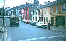
Castlerea
|
Castlerea An Caisleán Riabhach
|
|
|---|---|
| Town | |
 |
|
| Location in Ireland | |
| Coordinates: 53°46′00″N 8°30′00″W / 53.7667°N 8.5°WCoordinates: 53°46′00″N 8°30′00″W / 53.7667°N 8.5°W | |
| Country | Republic of Ireland |
| Province | Connacht |
| County | County Roscommon |
| Elevation | 82 m (269 ft) |
| Population (2011) | |
| • Urban | 3,055 |
| Irish Grid Reference | M670797 |
Castlerea (/ˌkæsəlˈreɪ/; Irish: An Caisleán Riabhach, meaning "brindled castle") is the second largest town in County Roscommon, Republic of Ireland. It is located in the west of the county and, as of 2011, has a population of 3,055. Roughly translated from Irish, Castlerea can mean Brindled Castle (Caisleán Riabhach) or King's Castle (Caisleán Rí). The town is built on the banks of the River Suck and the River Francis, both of which are tributaries of the River Shannon.
Clonalis House, located in the west of Castlerea, is the ancestral home of the Clan O'Conor, the last of the High Kings of Ireland. The O'Conor dynasty produced eleven high kings of Ireland and twenty-four kings of Connacht.
Theophilus Sandford, a member of Oliver Cromwell's army in Ireland, received a large allocation of lands confiscated from the O'Connor family as part of the Act for the Settlement of Ireland 1652. This package included Castlerea. Castlerea developed under the Sandfords, who established a distillery (at its height producing more than 20,000 of gallons of whiskey annually), a brewery, and a tannery. Sandford's descendants continued in power through the 19th century. The estate was later acquired by the Land Commission and the Congested Districts Board. The demesne in which it was set survives and is now enjoyed as a public park.
...
Wikipedia

