Cherokee National Forest
| Cherokee National Forest | |
|---|---|
|
IUCN category VI (protected area with sustainable use of natural resources)
|
|

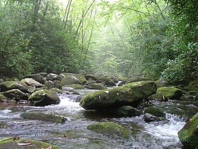
South Fork of Citico Creek in the Cherokee National Forest
|
|
| Location | Tennessee, United States |
| Nearest city | Johnson City, TN |
| Coordinates | 36°29′N 82°05′W / 36.483°N 82.083°WCoordinates: 36°29′N 82°05′W / 36.483°N 82.083°W |
| Area | 655,598 acres (2,653.11 km2) |
| Established | June 14, 1920 |
| Governing body | U.S. Forest Service |
| Website | Cherokee National Forest |
The Cherokee National Forest is a large National Forest created on June 14, 1920 and managed by the U.S. Forest Service and encompassing some 655,598 acres (2,653.11 km2).
The Cherokee National Forest headquarters are located in Cleveland, Tennessee.
The Cherokee National Forest mostly lies within eastern Tennessee, along the border with North Carolina, and comprises nearly the entire border area except for the section within Great Smoky Mountains National Park. The Cherokee National Forest has two separate sections: a northern region directly north of the Great Smoky Mountains National Park and a southern section directly south of the Smokies.
The Cherokee National Forest contains such notable sites as the Ocoee River (site of the 1996 Olympic whitewater events); 150 miles (240 km) of the Appalachian National Scenic Trail; Citico Creek Wilderness; Big Frog Mountain within Big Frog Wilderness, and surrounds both the Tennessee Valley Authority Watauga Reservoir and Wilbur Reservoir.
The forest is located in parts of ten counties in Tennessee and one county in North Carolina. In descending order of forestland area they are Polk, Monroe, Carter, Unicoi, Cocke, Johnson, Greene, Sullivan, Washington and McMinn counties in Tennessee and Ashe County in North Carolina.
...
Wikipedia

