Cheshire East
| Cheshire East | |||
|---|---|---|---|
| Borough and Unitary authority | |||
|
|||
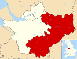
 Cheshire East shown within Cheshire |
|||
| Coordinates: 53°08′46″N 2°22′01″W / 53.146°N 2.367°WCoordinates: 53°08′46″N 2°22′01″W / 53.146°N 2.367°W | |||
| Sovereign state |
|
||
| Constituent country |
|
||
| Region | North West England | ||
| Ceremonial county |
|
||
| Established | 1 April 2009 | ||
| Administrative HQ | Sandbach (Westfields) | ||
| Government | |||
| • Type | Unitary authority | ||
| • Body | Cheshire East Council | ||
| • Leadership | Leader and cabinet | ||
| • Executive | Conservative | ||
| • Leader | Rachel Bailey | ||
| • Mayor | Olivia Hunter | ||
| • Chief Executive | Mike Suarez | ||
| Area | |||
| • Total | 450 sq mi (1,166 km2) | ||
| Area rank | 19th | ||
| Population (mid-2014 est.) | |||
| • Total | 374,179 | ||
| • Rank | 14th | ||
| • Density | 830/sq mi (321/km2) | ||
| • Ethnicity | 96.7% white | ||
| Time zone | Greenwich Mean Time (UTC+0) | ||
| • Summer (DST) | British Summer Time (UTC+1) | ||
| Postcode areas | CW (1, 2, 3, 4, 5, 10, 11, 12) SK (9, 10, 11, 12, 23) ST (7) WA (14, 15, 16) |
||
| Dialling codes | 01260 01270 01477 01565 01625 01606 |
||
| ISO 3166 code | GB-CHE | ||
| GSS code | E06000049 | ||
| NUTS 3 code | UKD62 | ||
| ONS code | 00EQ | ||
| Police area | Cheshire | ||
| Fire service | Cheshire | ||
| Ambulance service | North West | ||
| Website | www.cheshireeast.gov.uk | ||
Cheshire East is a unitary authority area with borough status in the ceremonial county of Cheshire, England. The local authority is Cheshire East Council.
The borough council was established in April 2009 as part of the 2009 structural changes to local government in England, by virtue of an order under the Local Government and Public Involvement in Health Act 2007. It is an amalgamation of the former boroughs of Macclesfield, Congleton and Crewe and Nantwich, and includes the functions of the former Cheshire County Council. The residual part of the disaggregated former County Council, together with the other three former Cheshire borough councils (Chester City, Ellesmere Port & Neston and Vale Royal) were, similarly, amalgamated to create the new unitary council of Cheshire West and Chester.
Cheshire East has historic links to textile mills of the industrial revolution, such as seen at Quarry Bank Mill. It is also home to Tatton Park, a historic estate that hosts RHS Show Tatton Park.
Cheshire East lies within North West England. It borders Cheshire West and Chester to the west, Greater Manchester to the north, Derbyshire to the east as well as Staffordshire and Shropshire to the south. It is home to the Cheshire Plain and the southern hills of the Pennines. The local geology is mostly glacial clay, as well as glacial sands and gravel.
...
Wikipedia


