Clackmannanshire
| Clackmannanshire Siorrachd Chlach Mhannainn |
|||
|---|---|---|---|
 |
|||
|
|||
| Coordinates: 56°10′N 3°45′W / 56.167°N 3.750°WCoordinates: 56°10′N 3°45′W / 56.167°N 3.750°W | |||
| Admin HQ |
Alloa (current) Clackmannan (historic) |
||
| Government | |||
| • Body | Clackmannanshire Council | ||
| • Control | SNP minority (council NOC) | ||
| • MPs |
|
||
| • MSPs |
|
||
| Area | |||
| • Total | 61.4 sq mi (159.0 km2) | ||
| Area rank | Ranked 30th | ||
| Population (mid-2015 est.) | |||
| • Total | 51,400 | ||
| • Rank | Ranked 29th | ||
| • Density | 840/sq mi (323/km2) | ||
| ONS code | S12000005 | ||
| ISO 3166 code | GB-CLK | ||
| Website | http://www.clacks.gov.uk/ | ||
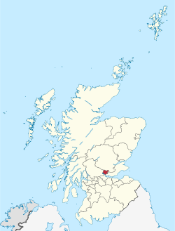
Clackmannanshire (/klækˈmænənˌʃɪər/ or /-ʃər/ ![]() listen ) is a historic county and council area in Scotland, bordering the council areas of Stirling, Fife and Perth & Kinross.
listen ) is a historic county and council area in Scotland, bordering the council areas of Stirling, Fife and Perth & Kinross.
The name is derived from three languages the first Scottish Gaelic: Chlach meaning "Stone", Mannan is a derivative of the Brythonic name of the Iron Age tribe the Manaw, who inhabited the area, and the English word shire. As Britain's smallest historic county, it is often nicknamed "The Wee County". When written, Clackmannanshire is commonly abbreviated to Clacks.
Clackmannan, the old county town, is named after the ancient stone associated with the pre-Christian deity Manau or Mannan. The stone now rests on a larger stone beside the Tollbooth and Mercat Cross at the top of Main street, Clackmannan.
Clackmannanshire became known for the weaving mills powered by the Hillfoots burns. Other industries included brewing, glass manufacture, mining and ship building. Now capitalising on its central position and transport links, Clackmannanshire attracts service industries and tourism.
...
Wikipedia

