Columbine Valley, Colorado
| Town of Columbine Valley, Colorado | |
|---|---|
| Statutory Town | |

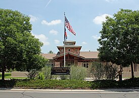
The Columbine Valley Town Hall.
|
|
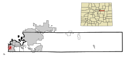
 Location in Arapahoe County and the state of Colorado |
|
| Coordinates: 39°35′58″N 105°01′51″W / 39.599580°N 105.030771°WCoordinates: 39°35′58″N 105°01′51″W / 39.599580°N 105.030771°W | |
| Country |
|
| State |
|
| County | Arapahoe County |
| Incorporated | July 2, 1959 |
| Government | |
| • Type | Statutory Town |
| Area | |
| • Total | 1 sq mi (2.7 km2) |
| • Land | 1 sq mi (2.7 km2) |
| • Water | 0 sq mi (0 km2) |
| Elevation | 5,344 ft (1,629 m) |
| Population (2010) | |
| • Total | 1,256 |
| • Density | 1,300/sq mi (470/km2) |
| Time zone | MST (UTC-7) |
| • Summer (DST) | MDT (UTC-6) |
| ZIP Code | 80123 |
| Area code(s) | Both 303 and 720 |
| INCITS place code | 0816385 |
| GNIS feature ID | 0182642 |
| Website | Town of Columbine Valley |
The Town of Columbine Valley is a Statutory Town located in western Arapahoe County, Colorado, United States. The town population was 1256 at the 2010 United States Census. Columbine Valley is a part of the Denver-Aurora-Lakewood, CO Metropolitan Statistical Area.
Columbine Valley is located at 39°35′58″N 105°2′14″W / 39.59944°N 105.03722°W (39.599665, -105.03736).
According to the United States Census Bureau, the town has a total area of 1.0 square mile (2.6 km2), all of it land.
As of the census of 2010, there were 1,256 people, 491 households, and 421 families residing in the town. There were 530 housing units. The racial makeup of the town was 95.3% White, 0.7% African American, 0.4% Native American, 1.5% Asian, 0% Pacific Islander, and 1.5% from two or more races. Hispanic or Latino of any race were 2.1% of the population.
...
Wikipedia
