Conway, NH
| Conway, New Hampshire | |
|---|---|
| Town | |

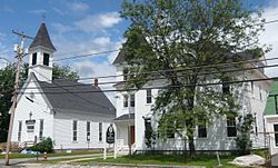
Town Hall (right) in Center Conway, one of the villages of Conway
|
|
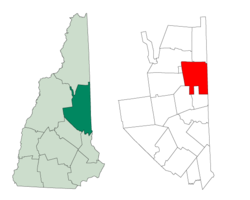
 Location in Carroll County, New Hampshire |
|
| Coordinates: 43°58′43″N 71°07′08″W / 43.97861°N 71.11889°WCoordinates: 43°58′43″N 71°07′08″W / 43.97861°N 71.11889°W | |
| Country | United States |
| State | New Hampshire |
| County | Carroll |
| Incorporated | 1765 |
| Government | |
| • Type | New England town |
| • Board of Selectmen | David Weathers, Chair Mary Carey Seavey Steven Porter John Colbath Carl Thibodeau |
| • Town Manager | Earl Sires |
| Area | |
| • Total | 71.7 sq mi (185.6 km2) |
| • Land | 69.4 sq mi (179.8 km2) |
| • Water | 2.2 sq mi (5.8 km2) 3.15% |
| Elevation | 465 ft (142 m) |
| Population (2010) | |
| • Total | 10,115 |
| • Density | 146/sq mi (56.3/km2) |
| Time zone | Eastern (UTC-5) |
| • Summer (DST) | Eastern (UTC-4) |
| ZIP code | 03818 |
| Area code(s) | 603 |
| FIPS code | 33-14660 |
| GNIS feature ID | 0873570 |
| Website | www |
Conway is a town in Carroll County, New Hampshire, United States. It is the most populous community in the county, and the most populous in the state north of Hanover. The population was 10,115 at the 2010 census, more than 1/5 of the total population of Carroll County. Parts of the White Mountain National Forest are in the west and north of the town. Cathedral Ledge (popular with climbers) and Echo Lake State Park are in the west. Villages within the town include Conway, North Conway, Center Conway, Redstone and Kearsarge, as well as a portion of the village of Intervale.
The region was once home to the Pequawket Indians, an Algonquian Abenaki tribe. Along the Saco River they fished, hunted or farmed, and lived in wigwams sheltered within . In 1642, explorer Darby Field of Exeter paddled up the Saco in a canoe, and would report seeing "Pigwacket," an Indian community stretching from present-day Conway to Fryeburg, Maine. The Pequawket tribe dwindled from disease, probably smallpox brought from abroad. In May 1725, during Dummer's War, 36 men from Dunstable, Massachusetts led by John Lovewell skirmished with the Pequawket. The Pequawket losses are not known but the result of the day's battle was the withdrawal of the tribe from the area.
...
Wikipedia
