Coosa River
| Coosa River | |
|
Fall colors on the Coosa River near Wetumpka, Alabama
|
|
| Country | United States |
|---|---|
| States | Alabama, Georgia |
| Source | junction of Oostanaula River and Etowah River |
| - location | at Rome, Georgia |
| - elevation | 575 ft (175 m) |
| - coordinates | 35°15′14″N 85°10′39″W / 35.25389°N 85.17750°W |
| Mouth | Alabama River |
| - location | near Montgomery, Alabama |
| - elevation | 121 ft (37 m) |
| - coordinates | 32°29′10″N 86°16′40″W / 32.48611°N 86.27778°WCoordinates: 32°29′10″N 86°16′40″W / 32.48611°N 86.27778°W |
| Length | 280 mi (451 km) |
| Basin | 10,100 sq mi (26,159 km2) |
| Discharge | for USGS gage 02411000, Coosa River at Jordan Dam near Wetumpka, AL |
| - average | 15,950 cu ft/s (452 m3/s) |
| - max | 256,000 cu ft/s (7,249 m3/s) |
| - min | 54 cu ft/s (2 m3/s) |
|
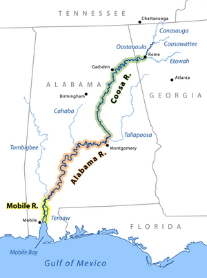
The Coosa River is the major tributary when it joins the Tallapoosa River near Wetumpka, Alabama to form the Alabama River.
|
|
The Coosa River is a tributary of the Alabama River in the U.S. states of Alabama and Georgia. The river is about 280 miles (450 km) long.
The Coosa River begins at the confluence of the Oostanaula and Etowah rivers in Rome, Georgia, and ends just northeast of the Alabama state capital, Montgomery, where it joins the Tallapoosa River to form the Alabama River just south of Wetumpka. Around 90% of the Coosa River's length is located in Alabama. Coosa County, Alabama, is located on the Coosa River.
The Coosa is one of Alabama's most developed rivers. Most of the river has been impounded, with Alabama Power, a unit of the Southern Company, maintaining seven dams on the Coosa River. The dams produce hydroelectric power , but are costly to some species endemic to the Coosa River.
Native Americans had been living on the Coosa Valley for millennia before Hernando de Soto and his men became the first Europeans to visit it in 1540. The Coosa chiefdom was one of the most powerful chiefdoms in the southeast at the time.
Over a century after the Spanish left the Coosa Valley, the British established strong trading ties with the Creek bands of the area around the late 17th century, much to the dismay of France. With a base in Mobile, Alabama, the French believed that the Coosa River was a key gateway to the entire South and they wanted to control the valley. The main transportation of the day was by boat. The convergence of the Coosa and Tallapoosa rivers near present-day Montgomery forms the Alabama River, which has its mouth at Mobile Bay, the port used by the French for travel around the Caribbean and to France. They wanted to retain control of both the Coosa and the Alabama rivers.
...
Wikipedia


