Costilla County, Colorado
| Costilla County, Colorado | |
|---|---|

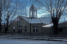
The Costilla County Courthouse in San Luis
|
|
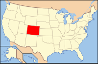
 Location in the U.S. state of Colorado |
|
 Colorado's location in the U.S. |
|
| Founded | November 1, 1861 |
| Seat | San Luis |
| Largest town | San Luis |
| Area | |
| • Total | 1,230 sq mi (3,186 km2) |
| • Land | 1,227 sq mi (3,178 km2) |
| • Water | 3.4 sq mi (9 km2), 0.3% |
| Population (est.) | |
| • (2015) | 3,584 |
| • Density | 2.9/sq mi (1/km²) |
| Congressional district | 3rd |
| Time zone | Mountain: UTC-7/-6 |
| Website | www |
| Footnotes: Colorado's first permanent settlement | |
Costilla County is the ninth-least populous of the 64 counties in the U.S. state of Colorado. As of the 2010 census, the population was 3,524. The county seat is San Luis, the oldest town in Colorado.
Costilla County was the first area of Colorado to be settled by European-Americans. Hispanic settlers from Taos, New Mexico, officially established San Luis on April 9, 1851. Costilla County was one of the original 17 counties created by the Territory of Colorado on November 1, 1861. The county was named for the Costilla River. Although San Miguel was originally designated the county seat, the county government was moved to San Luis in 1863.
The county's original boundaries extended over much of south-central Colorado. Much of the northern portion became part of Saguache County in 1866, and the western portions were folded into Hinsdale and Rio Grande counties in 1874. Costilla County arrived at its modern boundaries in 1913 when Alamosa County was created from its northwest portions.
According to the U.S. Census Bureau, the county has a total area of 1,230 square miles (3,200 km2), of which 1,227 square miles (3,180 km2) is land and 304 square miles (790 km2) (0.3%) is water.
As of the census of 2000, there were 3,663 people, 1,503 households, and 1,029 families residing in the county. The population density was 3 people per square mile (1/km²). There were 2,202 housing units at an average density of 2 per square mile (1/km²). The racial makeup of the county was 60.91% White, 0.79% Black or African American, 2.48% Native American, 1.01% Asian, 0.14% Pacific Islander, 29.46% from other races, and 5.21% from two or more races. 67.59% of the population were Hispanic or Latino of any race.
...
Wikipedia
