Csenger District
|
Csenger District Csengeri járás |
||
|---|---|---|
| Districts of Hungary | ||
|
||
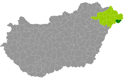
 Csenger District within Hungary and Szabolcs-Szatmár-Bereg County. |
||
| Country |
|
|
| County | Szabolcs-Szatmár-Bereg | |
| District seat | Csenger | |
| Area | ||
| • Total | 246.51 km2 (95.18 sq mi) | |
| Area rank | 11th in Szabolcs-Szatmár-Bereg | |
| Population (2011 census) | ||
| • Total | 13,485 | |
| • Rank | 13th in Szabolcs-Szatmár-Bereg | |
| • Density | 55/km2 (140/sq mi) | |
Csenger District (Hungarian: Csengeri járás) is a district in eastern part of Szabolcs-Szatmár-Bereg County. Csenger is also the name of the town where the district seat is found. The district is located in the Northern Great Plain Statistical Region. This district is a part of Szatmár historical and geographical region.
Csenger District borders with Fehérgyarmat District to the north, ![]() Romania (Satu Mare County) to the east and south, Mátészalka District to the west. The number of the inhabited places in Csenger District is 11.
Romania (Satu Mare County) to the east and south, Mátészalka District to the west. The number of the inhabited places in Csenger District is 11.
(ordered by population, as of 1 January 2013)
The bolded municipality is city.
Coordinates: 47°50′00″N 22°37′00″E / 47.8333°N 22.6167°E
...
Wikipedia

