Despeñaperros
| Despeñaperros Natural Park | |
|---|---|
 |
|
| Location | Andalusia, Spain |
| Coordinates | 38°23′10″N 3°30′25″W / 38.38611°N 3.50694°WCoordinates: 38°23′10″N 3°30′25″W / 38.38611°N 3.50694°W |
| Area | 76.49 square kilometres (29.53 sq mi) |
| Established | 1989 |
| Governing body | Ministry of the Environment |
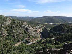
Despeñaperros (literally, [cliff where] dogs plunge) is a gorge or canyon carved out by the Despeñaperros River. It is located in the municipality of Santa Elena in the northern portion of the province of Jaén, Spain. The 76.49-square-kilometre (29.53 sq mi) area was declared a natural park by the Andalusian Autonomous Government, primarily for its geology and landscape, but also for its notable flora and fauna.
The gorge has steep walls, some more than 500 metres (1,600 ft) in height. It has historically been much used by humans as a natural pass through the Sierra Morena, constituting a principal path of connection between Andalusia and the Meseta Central, Castile-La Mancha, and the rest of Spain. Today the Despeñaperros is the route of the Autovía A-4 and of one of Andalusia's most important railway connections to the rest of Spain. Until the 1992 construction of the high-speed Puertollano–Córdoba route (90 kilometres (56 mi) to the west), this rail route was second in importance only to the Mérida–Seville line in terms of connecting from Andalusia to the rest of Spain.
...
Wikipedia
