Dusit
|
Dusit ดุสิต |
|
|---|---|
| Khet | |

|
|
 Khet location in Bangkok |
|
| Coordinates: 13°46′37″N 100°31′14″E / 13.77694°N 100.52056°ECoordinates: 13°46′37″N 100°31′14″E / 13.77694°N 100.52056°E | |
| Country | Thailand |
| Province | Bangkok |
| Seat | Dusit |
| Khwaeng | 5 |
| Area | |
| • Total | 10.7 km2 (4.1 sq mi) |
| Population (2000) | |
| • Total | 175,658 |
| • Density | 16,416.6/km2 (42,519/sq mi) |
| Time zone | ICT (UTC+7) |
| Postal code | 10300 |
| Geocode | 1002 |
Dusit (Thai: ดุสิต; IPA: [dù.sìt]) is one of the 50 districts (khet) of Bangkok, Thailand.
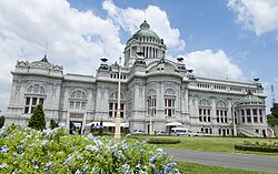
The district is the administrative centre of the kingdom, as both the National Assembly and royal palace are in this district, as are several ministries. It is connected to Rattanakosin Island by Ratchadamnoen Avenue (literally, "royal way for travelling").
Neighbouring districts are, clockwise from north, Bang Sue, Phaya Thai, Ratchathewi, Pathum Wan, Pom Prap Sattru Phai, Phra Nakhon, and across the Chao Phraya River, the district of Bang Phlat.
The district was established by King Chulalongkorn, who wanted to escape the confines of Rattanakosin Island. Vimanmek Palace was constructed in 1900 completely out of teak, and was used as a royal palace for a short time, but was abandoned in 1908. Reconstructed in 1992, it is now a major tourist attraction of the district. Chitralada Palace was built by King Vajiravudh (Rama VI), and was a residence of King Bhumibol Adulyadej. The large park around the palace was used by the King for agricultural research.
...
Wikipedia
