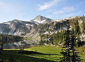
Eagle Cap Wilderness
| Eagle Cap Wilderness | |
|---|---|
|
IUCN category Ib (wilderness area)
|
|

Mirror Lake in the Eagle Cap Wilderness
|
|
| Location | Wallowa / Union / Baker counties, Oregon, United States |
| Nearest city | Enterprise, Oregon |
| Coordinates | 45°14′32″N 117°26′30″W / 45.24222°N 117.44167°WCoordinates: 45°14′32″N 117°26′30″W / 45.24222°N 117.44167°W |
| Area | 361,446 acres (146,272 ha) |
| Established | 1940 |
| Governing body | U.S. Forest Service |
Eagle Cap Wilderness is a wilderness area located in the Wallowa Mountains of northeastern Oregon (United States), within the Wallowa–Whitman National Forest. The wilderness was established in 1940. In 1964, it was included in the National Wilderness Preservation System. A boundary revision in 1972 added 73,000 acres (30,000 ha) and the Wilderness Act of 1984 added 66,100 acres (26,700 ha) resulting in a current total of 361,446 acres (146,272 ha; 565 sq mi), making Eagle Cap by far Oregon's largest wilderness area.
Eagle Cap Wilderness is named after a peak in the Wallowa Mountains, which were once called the Eagle Mountains. At 9,572 feet (2,918 m) Eagle Cap was incorrectly thought to be the highest peak in the range, hence the name.
The Eagle Cap Wilderness is characterized by high alpine lakes and meadows, bare granite peaks and ridges, and U-shaped glacial valleys. Thick timber is found in the lower valleys and scattered alpine timber on the upper slopes. Elevations in the wilderness range from approximately 3,000 feet (914 m) in lower valleys to 9,838 feet (2,999 m) at the summit of Sacajawea Peak with 30 other summits exceeding 8,000 feet (2,400 m). The wilderness is home to Legore Lake, the highest lake above sea level in Oregon at 8,950 feet (2,728 m), as well as almost 60 alpine lakes (9 of which are above 8,000 feet), and more than 37 miles (60 km) of streams.
The Eagle Cap Wilderness and surrounding country in the Wallowa–Whitman National Forest was first occupied by the ancestors of the Nez Perce Indian tribe around 1400 AD, and later by the Cayuse, the Shoshone, and Bannocks. The wilderness was used as hunting grounds for bighorn sheep and deer and to gather huckleberries. It was the summer home to the Joseph Band of the Nez Perce tribe. 1860 marked the year the first settlers moved into the Wallowa Valley. In 1930, the Eagle Cap was established as a primitive area and in 1940 earned wilderness designation.
...
Wikipedia

