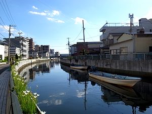
Ebi River
| Ebi River | |
|---|---|

A section of the Ebi River
|
|
| Native name | 海老川 |
| Country | Japan |
| Basin features | |
| Main source | Funabashi, Chiba Prefecture |
| River mouth |
Pacific Ocean 0 m (0 ft) |
| Physical characteristics | |
| Length | 2.67 km (1.66 mi) |
Coordinates: 35°41′14.53″N 139°59′17.49″E / 35.6873694°N 139.9881917°E
The Ebi River (海老川 Ebigawa) is a river in Funabashi, Chiba Prefecture, Japan. It is 2.67 kilometers (1.66 mi) in length and has a drainage area of 260 square kilometers (100 sq mi). Under the Japan Rivers Act of 1906 the river is designated as a Class 2 River. The Ebi originates near Takanechō district of Funabashi and flows directly south into Tokyo Bay. The river has numerous small tributaries and serves as an important part of the drainage network of Funabashi.
The Otakisan Konzō-ji temple of the Shingon Buzan sect is near the origin of the Ebi River. The Ebi River is known as a place to view cherry blossoms in spring.
The Ebi River was called the Ōigawa River (太白川) earlier in history. It current name, "ebi", is the Japanese word for "shrimp". By legend the river was renamed when residents of the area presented Minamoto no Yoritomo with a gift of shrimp. The river was larger in the Edo period. Riverboats on the Ebi carried goods to and from the Edo capitol.
...
Wikipedia
