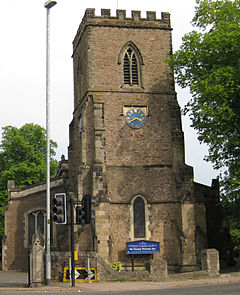
Enderby, Leicestershire
| Enderby | |
|---|---|
 St John the Baptist parish church |
|
| Enderby shown within Leicestershire | |
| Population | 6,314 (2011 Census) |
| OS grid reference | SK596088 |
| Civil parish |
|
| District | |
| Shire county | |
| Region | |
| Country | England |
| Sovereign state | United Kingdom |
| Post town | Leicester |
| Postcode district | LE19 |
| Dialling code | 0116 |
| Police | Leicestershire |
| Fire | Leicestershire |
| Ambulance | East Midlands |
| EU Parliament | East Midlands |
| UK Parliament | |
| Website | Enderby Parish Council |
Enderby is a small town and civil parish in Leicestershire, on the southwest outskirts of the city of Leicester. The parish includes the neighbourhood of St John's, which is east of the village separated from it by the M1 motorway. The 2011 Census recorded the parish's population as 6,314.
The village is either side of the B4114 between Fosse Shopping Park and Narborough. The parish includes Fosse Shopping Park, Grove Park Commercial Centre and Everards Brewery.
The parish is bounded by the City of Leicester and the civil parishes of Braunstone Town, Glen Parva, Lubbesthorpe, Narborough and Whetstone.
The course of the Fosse Way Roman road passes through the parish. Near St John's is the deserted village of Alderby by the River Soar.
Enderby Hall was the ancestral home of the Smith family when the paternal line ended. The hall was left to Charles Loraine who took the name Charles Loraine Smith.
Enderby was in the UK Parliament constituency of Blaby between 1974 and 2010, when this was replaced with the South Leicestershire constituency. It is currently represented in the House of Commons by Alberto Costa of the Conservative Party.
...
Wikipedia

