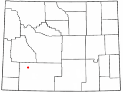
Farson, Wyoming
| Farson, Wyoming | |
|---|---|
| CDP | |
 Location of Farson, Wyoming |
|
| Coordinates: 42°10′19″N 109°25′12″W / 42.17194°N 109.42000°WCoordinates: 42°10′19″N 109°25′12″W / 42.17194°N 109.42000°W | |
| Country | United States |
| State | Wyoming |
| County | Sweetwater |
| Area | |
| • Total | 77.8 sq mi (201.4 km2) |
| • Land | 75.4 sq mi (195.4 km2) |
| • Water | 2.4 sq mi (6.1 km2) |
| Elevation | 6,594 ft (2,010 m) |
| Population (2010) | |
| • Total | 313 |
| • Density | 4.2/sq mi (1.6/km2) |
| Time zone | Mountain (MST) (UTC-7) |
| • Summer (DST) | MDT (UTC-6) |
| ZIP code | 82932 |
| Area code(s) | 307 |
| FIPS code | 56-26055 |
| GNIS feature ID | 1588389 |
Farson is a census-designated place (CDP) in Sweetwater County, Wyoming, United States. The population was 313 at the 2010 census.
Farson is located at 42°10′19″N 109°25′12″W / 42.17194°N 109.42000°W (42.171927, -109.420096).
According to the United States Census Bureau, the CDP has a total area of 77.8 square miles (201.4 km²), of which, 75.4 square miles (195.4 km²) of it is land and 2.3 square miles (6.1 km²) of it (3.02%) is water.
Farson lies at the intersection of US 191 and Wyoming Highway 28 (the South Pass Highway). It is 40 miles north of Rock Springs and about 45 miles southwest of South Pass.
As of the census of 2000, there were 242 people, 96 households, and 69 families residing in the CDP. The population density was 3.2 people per square mile (1.2/km²). There were 118 housing units at an average density of 1.6/sq mi (0.6/km²). The racial makeup of the CDP was 96.28% White, 0.83% African American, 1.65% from other races, and 1.24% from two or more races. Hispanic or Latino of any race were 5.37% of the population.
...
Wikipedia
