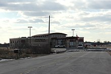
Fond du Lac County Airport
| Fond du Lac County Airport | |||||||||||||||
|---|---|---|---|---|---|---|---|---|---|---|---|---|---|---|---|

Terminal Building
|
|||||||||||||||

Airport and sign
|
|||||||||||||||
| Summary | |||||||||||||||
| Airport type | Public | ||||||||||||||
| Owner | Fond du Lac County | ||||||||||||||
| Serves | Fond du Lac, Wisconsin | ||||||||||||||
| Elevation AMSL | 808 ft / 246 m | ||||||||||||||
| Coordinates | 43°46′16″N 088°29′18″W / 43.77111°N 88.48833°WCoordinates: 43°46′16″N 088°29′18″W / 43.77111°N 88.48833°W | ||||||||||||||
| Map | |||||||||||||||
| Location of airport in Wisconsin / United States | |||||||||||||||
| Runways | |||||||||||||||
|
|||||||||||||||
| Statistics | |||||||||||||||
|
|||||||||||||||
|
Source: Federal Aviation Administration
|
|||||||||||||||
| Aircraft operations (2014) | 63,200 |
|---|---|
| Based aircraft (2017) | 62 |
Fond du Lac County Airport, (IATA: FLD, ICAO: KFLD, FAA LID: FLD) is a county owned public use airport located 1 mile (2 km) west of the central business district of Fond du Lac, Wisconsin, a city in Fond du Lac County, Wisconsin, United States. It is included in the Federal Aviation Administration (FAA) National Plan of Integrated Airport Systems for 2017–2021, in which it is categorized as a regional general aviation facility. The airport is home to EAA chapter 572.
Fond du Lac County Airport covers an area of 586 acres (237 ha) at an elevation of 808 feet (246 m) above mean sea level. It has two runways: 18/36 is 5,941 by 100 feet (1,811 x 30 m) with an asphalt surface and 9/27 is 3,602 by 75 feet (1,098 x 23 m) with an asphalt surface. The Airport has one FBO, the Fond du Lac Skyport.
For the 12-month period ending July 23, 2014, the airport had 63,200 aircraft operations: 5% air taxi, 95% general aviation and less than 1% military. In July 2017, there were 62 aircraft based at this airport: 55 single-engine, 6 multi-engine and 1 jet aircraft.
...
Wikipedia


