Frostenden
| Frostenden | |
|---|---|
 Frostenden All Saints |
|
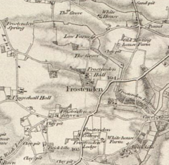
 19th Century Map of Frostenden |
|
| Frostenden shown within Suffolk | |
| Population | 167 2011 Census |
| Civil parish |
|
| Shire county |
|
| Region | |
| Country | England |
| Sovereign state | United Kingdom |
| Police | Suffolk |
| Fire | Suffolk |
| Ambulance | East of England |
| EU Parliament | East of England |
Frostenden is a small village in Suffolk, England. It is located around 1 mile south-west of the neighbouring town, Wrentham. Its church, All Saints, is one of 38 existing round-tower churches in Suffolk. It is situated west to the A12 and can be seen from this major road.
In 1870, Frostenden was described by John Marius Wilson in the "Imperial Gazetteer of England and Wales":
"The property is divided among a few. The living is a rectory in the diocese of Norwich. Value, £348. Patron, Thomas Barne, Esq. The church is chiefly early English; has a round western tower; and contains an early English piscina and a later English font. Charities, £28."
Frostenden was previously part of the Blything hundred district, a form of county division used up until the end of the 19th Century. Blything was the largest of the 21 Suffolk hundreds, and was composed of 48 parishes.
In 1881, the population was reported as being 386 but in 2011 the Frostenden population had decreased to 167. According to the 2011 census there were 89 males and 78 females living in the parish. As seen on the population graph, the population has steadily declined over the past century, and as of 2011, had reached its lowest level in an official census. The highest population recorded was in the 1851 census with a total of 456 people.
The graph of "Recorded Historical Population of Frostenden" gives an idea of the population variation of Frostenden between the 11th and 17th centuries. The dates used are; 1086, 1327, 1524 and 1603. It is however important to note from this data that the figures given for 1327 and 1524 are representative of the total number of tax payers within the area, rather than the total net population, which would indicate the population was actually much higher.
Total Population of Frostenden Civil Parish, Suffolk, as reported by the Census of Population from 1801 to 2011.
This graph shows the population variation of the parish of Frostenden from 4 separate dates.
The 1831 census data shows a predominantly agriculture-focused population, with 70% of the workforce listed as "Agricultural Labourers", though two of the other categories can be linked to agriculture as "Farmers employing Labourers" and "Farmers not employing Labourers". Maps from the 19th century show that the area was particularly rural with several farms listed within the village.
Within the population of 386 in 1881, 207 of those had listed occupations on the census. The main industry seen in this data was agriculture, at 33% of the total workforce - compared with less than 3% of the total workforce from the 2011 census. The largest industry for the female workforce in 1881 was Domestic Service, with 17 of the women working in this industry.
...
Wikipedia

