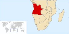
Geography of Angola
 
|
|
| Continent | Africa |
|---|---|
| Region | Southern Africa |
| Coordinates | 12°30′S 18°30′E / 12.500°S 18.500°E |
| Area | Ranked 22nd |
| • Total | 1,246,700 km2 (481,400 sq mi) |
| Coastline | 1,600 km (990 mi) |
| Borders | Land boundaries: 5,369 km DROC 2,646 km Republic of Congo 231 km Namibia 1,427 km Zambia 1,065 km |
| Highest point | Mount Moco, 2,620 m |
| Lowest point | Atlantic Ocean, sea level |
| Longest river | Congo River, 4,344 m |
| Terrain | narrow coastal plains, hills and mountains, high plains |
| Natural Resources | petroleum, diamonds, iron ore, phosphates, copper, feldspar, gold, bauxite, uranium |
| Natural Hazards | occasional heavy rainfall with accompanying floods |
| Environmental Issues | deforestation, overgrazing of meadows, air pollution, waste disposal |
| Land use | (2012) |
|---|---|
| Arable land | 3.93% |
| Permanent crops | 0.23% |
| Other | 95.84% |
Angola is located on the western Atlantic Coast of southern Africa between Namibia and the Republic of the Congo. It also is bordered by the Democratic Republic of the Congo and Zambia to the east. The country consists of a sparsely watered and somewhat sterile coastal plain extending inland for a distance varying from 50 to 160 km (31 to 99 mi). Slightly inland and parallel to the coast is a belt of hills and mountains and behind those a large plateau.
The rock formations of Angola are met with in three distinct regions:
The central plateau consists of ancient crystalline rocks with granites overlain by non-fossiliferous sandstones and conglomerates of Paleozoic age. The outcrops are largely hidden under laterite. The median zone is composed largely of crystalline rocks with granites and some Palaeozoic unfossiliferous rocks. The littoral zone contains the only fossiliferous strata. These are of Tertiary and Cretaceous ages, the latter rocks resting on a reddish sandstone of older date. The Cretaceous rocks of the Dombe Grande region (near Benguela) are of Albian age and belong to the Acanthoceras mamillari zone. The beds containing Schloenbachia inflata are referable to the Gault. Rocks of Tertiary age are met with at Dombe Grande, Namibe and near Luanda. The sandstones with gypsum, copper and sulfur of Dombe are doubtfully considered to be of Triassic age. Recent eruptive rocks, mainly basalts, form a line of hills almost bare of vegetation between Benguela and Namibe. Nepheline basalts and liparites occur at Dombe Grande. The presence of gum copal in considerable quantities in the superficial rocks is characteristic of certain regions. The geology and outline of the west coast of Angola is related to the opening of South Atlantic that started in the Early Cretaceous and continued until the Eocene, which is reflected in the invertebrate and vertebrate fossil fauna.. The diamond mine of Catoca preserved unexpected ancient dinosaur, mammal and crocodylomorph tracks with 128 Million years.
...
Wikipedia
