Goose Island, Chicago

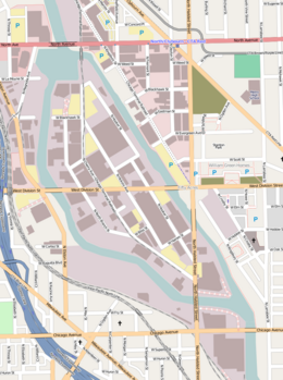
Street map of Goose Island
|
|
| Geography | |
|---|---|
| Location | Chicago River |
| Coordinates | 41°54′16″N 87°39′15″W / 41.90444°N 87.65417°WCoordinates: 41°54′16″N 87°39′15″W / 41.90444°N 87.65417°W |
| Area | 160 acres (65 ha) |
| Length | 1.5 mi (2.4 km) |
| Width | 0.5 mi (0.8 km) |
| Administration | |
|
United States
|
|
| State | Illinois |
| City | Chicago |
Goose Island is a 160 acres (0.65 km2) artificial island in Chicago, Illinois, formed by the North Branch of the Chicago River on the west and the North Branch Canal on the east. It is about 1.5 miles (2.4 km) long and 0.5 miles (0.80 km) across at its widest point.
The name may have originally referred to a small natural island at the north side of the confluence of the North and South Branches of the Chicago River that was home to seasonal flocks of birds. In the late 1840s, the surrounding area was on the fringes of Chicago and a group of Irish immigrants started squatting on the unoccupied land around what is now Kinzie Street, between Orleans Street and the river. This settlement may have been known as Kilgubbin, after an area of County Cork that had been home to many of the immigrants. The squatters eventually moved a short distance north to an area on the east side of the river between Chicago Avenue and Division Street, site of the present-day Goose Island. The original Goose Island had been dredged away by 1865.
The land that was to become the present-day Goose Island lies on a bend in the Chicago River between North Avenue on the north and Chicago Avenue on the south. In 1853, William B. Ogden, Chicago's first mayor, formed the Chicago Land Company, which purchased land on the east side of the river to excavate clay for brick-making. Starting from the south, workers excavated a channel northwards, and by 1857 the channel had rejoined the river forming a shortcut past the bend in the river. The channel was eventually dredged to 50 feet (15 m) wide and 10 feet (3.0 m) deep to make it navigable, and it became known as the North Branch Canal, or Ogden's Canal. The island thus created was also sometimes nicknamed Ogden's Island, a name that some Chicago aldermen proposed to make the official name of the island in 1891. The name may refer to the earlier location of the Kilgubbin settlement close to the original Goose Island, or it may have been in reference to the flocks of geese kept by the settlers on the island.
The settlers were eventually joined by Polish and German immigrants to the city. For most of the residents, daily life hovered between rural and urban, with many raising livestock while also working in nearby factories. Over 100 units of housing were built in a three-block area to accommodate the new residents and taverns and bars opened.
...
Wikipedia
