Guigang
|
Guigang 贵港市 • Gveigangj Si |
|
|---|---|
| Prefecture-level city | |

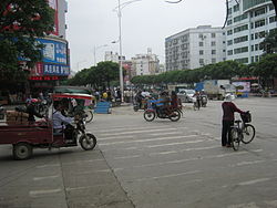
Guigang in 2013. Jiefang Road (解放路)
|
|
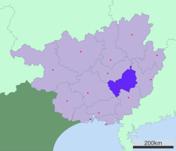
 Location of Guigang City jurisdiction in Guangxi |
|
| Location in China | |
| Coordinates: 23°05′46″N 109°36′33″E / 23.09611°N 109.60917°E | |
| Country | People's Republic of China |
| Region | Guangxi |
| Area | |
| • Total | 10,595 km2 (4,091 sq mi) |
| Elevation | 45 m (147 ft) |
| Population (2004) | |
| • Total | 4,400,000 |
| Time zone | China Standard (UTC+8) |
| Postal code | 537100 |
| Area code(s) | 0775 |
| Licence plate prefixes | 桂R |
| Website | http://www.gxgg.gov.cn/ |
Guigang (simplified Chinese: ; traditional Chinese: ; pinyin: Guìgǎng; literally: "Distinguished Harbor"; Zhuang: Gveigangj) is a prefecture-level city in eastern Guangxi in the People's Republic of China. Prior to 1988, it was known as Gui County or Guixian (simplified Chinese: ; traditional Chinese: ; pinyin: Guìxiàn).
Guigang is located in eastern Guangxi. It is located between Guangxi's five major cities: Nanning, Guilin, Liuzhou, Beihai, and Wuzhou. Its location makes it a major transportation and business hub, connecting central China with the south, especially Hong Kong and Macau. Guigang has a rail line, several major highways, an expressway, and most importantly a large port on the Xi River, its direct connection to the Pearl River Delta. The area is 10,595 km2 (4,091 sq mi).
Climate is sub-tropical and monsoonal with an annual mean temperature of 21 °C (70 °F). Annual precipitation is 1,428 mm (56.2 in).
Guigang has 1 county-level city, 3 urban districts, and 1 counties.
...
Wikipedia

