Haha-jima
| Native name: Japanese: 母島 | |
|---|---|

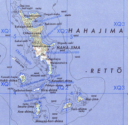
Map of the Hahajima Rettō (Imōtojima is mislabeled as Tori-shima)
|
|
| Geography | |
| Location | Pacific Ocean |
| Coordinates | 26°39′N 142°10′E / 26.650°N 142.167°E |
| Archipelago | Ogasawara Islands |
| Area | 19.88 km2 (7.68 sq mi) |
| Highest elevation | 462 m (1,516 ft) |
| Highest point | Chibusayama |
| Administration | |
|
Japan
|
|
| Tokyo Metropolis | |
| Demographics | |
| Population | 450 (2009) |
| Pop. density | 22.6 /km2 (58.5 /sq mi) |
| Ethnic groups | Japanese |
Hahajima (母島?, meaning "Mother Island") is the second-largest island of the Ogasawara Islands or Bonin Islands south of the Japanese main island chain. It is about 21 km2 (8 sq mi) in area with a population of 440.
The highest points are Chibusayama, (literally "Breast Mountain"), approximately 462 metres (1,516 ft), and Sakaigatake, 443 metres (1,453 ft). The largest island of the group, Chichijima is located approximately 50 km (31 mi) to the north. Together with nearby smaller islands like Anejima and Imōtojima and Mukōjima, Hahajima forms the Hahajima Rettō (母島列島), or in former times, the "Baily Group".
The island is within the political boundaries of Ogasawara Village, Ogasawara Subprefecture, Tokyo, Japan.
The first European discovery of the Bonin Islands is said to have taken place in 1543, by the Spanish explorer, Bernardo de la Torre. Hahajima was originally called Coffin Island or Hillsborough Island and settled by Europeans before becoming part of Japan. In World War II, the Japanese government removed the locals and fortified the island; it was the target of several attacks by US forces during World War II. What is left of the defense works is now one of the tourist attractions of the island. The island can be reached by ferry in about two hours from Chichijima. The economy of Hahajima is based on commercial fishing, as well as a state-run rum distillery.
Today Hahajima has a population of 450, but the population was 1546 in 1904 and 1905 in 1940. There is one road from the (now-abandoned) village of Kitamura (北村) at the north end of the island to the village of Okimura (沖村) - formerly "Newport" at the southern end of the island, where the harbor is located. Ogasawara Village operates the island's public elementary and junior high schools. Tokyo Metropolitan Government Board of Education operates Ogasawara High School[1] on nearby Chichijima.
...
Wikipedia
