Haute-Marne
| Haute-Marne | ||
|---|---|---|
| Department | ||

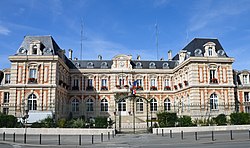
Prefecture building of the Haute-Marne department, in Chaumont
|
||
|
||
 Location of Haute-Marne in France |
||
| Coordinates: 48°05′N 05°15′E / 48.083°N 5.250°ECoordinates: 48°05′N 05°15′E / 48.083°N 5.250°E | ||
| Country | France | |
| Region | Grand Est | |
| Prefecture | Chaumont | |
| Subprefectures |
Langres Saint-Dizier |
|
| Government | ||
| • President of the General Council | Bruno Sido | |
| Area | ||
| • Total | 6,211 km2 (2,398 sq mi) | |
| Population (2013) | ||
| • Total | 181,521 | |
| • Rank | 91st | |
| • Density | 29/km2 (76/sq mi) | |
| Time zone | CET (UTC+1) | |
| • Summer (DST) | CEST (UTC+2) | |
| Department number | 52 | |
| Arrondissements | 3 | |
| Cantons | 17 | |
| Communes | 429 | |
| ^1 French Land Register data, which exclude estuaries, and lakes, ponds, and glaciers larger than 1 km2 | ||
Haute-Marne (French pronunciation: [ot.maʁn]) is a department in the northeast of France named after the Marne River.
Haute-Marne is one of the original 83 departments created during the French Revolution on March 4, 1790. It was created from parts of the former provinces of Champagne, Burgundy, Lorraine and Franche-Comté.
In March 1814 the departmental prefecture, Chaumont, was the unwitting witness to the end of the First Empire. On 1 March, Prussia, Russia, the United Kingdom and Austria signed an accord forbidding any individual peace deal with Napoleon I, and to fight until his final defeat.
During World War II, Haute-Marne was partitioned under German occupation. The canal which runs from the Marne to the Saône served as a border, dividing the department into east and west. The east was a "reserved zone", intended for the creation of a new German (Ripuarian) state, whereas to the west would be the traditional "occupied zone". Haute-Marne was finally liberated by the Allies, in the form of the division of General Leclerc, between August and September 1944.
...
Wikipedia

