Holyoke, Colorado
| Holyoke, Colorado | |
|---|---|
| Home Rule Municipality | |

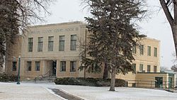
Phillips County Courthouse (2013)
|
|
| Motto: "It's not what you show, it's what you grow." | |
 Location within Phillips County and Colorado |
|
| Coordinates: 40°34′55″N 102°18′4″W / 40.58194°N 102.30111°WCoordinates: 40°34′55″N 102°18′4″W / 40.58194°N 102.30111°W | |
| Country |
|
| State |
|
| County | Phillips |
| Incorporated | May 31, 1888 |
| Government | |
| • Type | Home Rule Municipality |
| Area | |
| • Total | 1.7 sq mi (4.5 km2) |
| • Land | 1.7 sq mi (4.5 km2) |
| • Water | 0 sq mi (0 km2) |
| Elevation | 3,750 ft (1,143 m) |
| Population (2013) | |
| • Total | 1,965 |
| • Density | 1,200/sq mi (440/km2) |
| Time zone | MST (UTC-7) |
| • Summer (DST) | MDT (UTC-6) |
| ZIP code | 80734 |
| Area code(s) | 970 |
| FIPS code | 08-37270 |
| GNIS feature ID | 0182823 |
| Website | Holyoke CoC |
Holyoke is the Home Rule Municipality that is the county seat and the most populous municipality of Phillips County, Colorado, United States. The city population was 2,313 at the 2010 census.
The city is named after Holyoke, Massachusetts.
Holyoke is located at 40°34′55″N 102°18′4″W / 40.58194°N 102.30111°W (40.582002, -102.301056). According to the United States Census Bureau, the city has a total area of 1.7 square miles (4.4 km2), all of it land.
As of the census of 2000, there were 2,261 people, 896 households, and 594 families residing in the city. The population density was 1,300.3 people per square mile (501.7/km²). There were 980 housing units at an average density of 563.6 per square mile (217.5/km²). The racial makeup of the city was 89.61% White, 0.04% African American, 0.31% Native American, 0.57% Asian, 8.09% from other races, and 1.37% from two or more races. Hispanic or Latino of any race were 20.39% of the population.
...
Wikipedia
