Hope, Arkansas
| Hope, Arkansas | |
|---|---|
| City | |

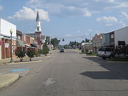
Downtown Hope.
|
|
| Motto: A Slice of the Good Life | |
 |
|
| Coordinates: 33°40′4″N 93°35′24″W / 33.66778°N 93.59000°WCoordinates: 33°40′4″N 93°35′24″W / 33.66778°N 93.59000°W | |
| Country | United States |
| State | Arkansas |
| County | Hempstead |
| Founded | 1875 |
| Government | |
| • Type | Council-Manager |
| Area | |
| • City | 10.1 sq mi (26 km2) |
| • Land | 10.0 sq mi (25.9 km2) |
| • Water | 0.1 sq mi (0.2 km2) |
| Elevation | 351 ft (107 m) |
| Population (2014) | |
| • City | 10,004 |
| • Metro | 32,057 |
| Time zone | CST (UTC-6) |
| • Summer (DST) | CDT (UTC-5) |
| ZIP codes | 71801-71802 |
| Area code(s) | 870 |
| FIPS code | 05-33190 |
| GNIS feature ID | 0057940 |
| Website | Official website |
Hope is a city in Hempstead County in southwestern Arkansas, United States. Hope is the county seat of Hempstead County and the principal city of the Hope Micropolitan Statistical Area, which includes all of Hempstead and Nevada counties. Hope is the birthplace of two long-serving Arkansas governors: Bill Clinton (who went on to become the 42nd President of the United States after the 1992 election) and Mike Huckabee (who ran for the Republican presidential nomination in 2008 and 2016).
Hope began in 1873, when a railroad was built through the area. The town was named for Hope Loughborough, the daughter of a railroad executive.
According to the United States Census Bureau, the city has a total area of 10.1 square miles (26 km2), of which, 10.0 square miles (26 km2) of it is land and 0.1 square miles (0.26 km2) of it (0.60%) is water.
The climate is characterized by hot, humid summers and generally mild to cool winters. According to the Köppen Climate Classification system, Hope has a humid subtropical climate, abbreviated Cfa on climate maps.
As of the census of 2000, there were 10,616 people, 3,961 households, and 2,638 families residing in the city. The population density was 1,061.9 people per square mile (409.9/km²). There were 4,301 housing units at an average density of 430.2 per square mile (166.1/km²). The racial makeup of the city was 47.71% White, 43.17% Black or African American, 0.38% Native American, 0.30% Asian, 0.03% Pacific Islander, 6.63% from other races, and 1.78% from two or more races. 13.48% of the population were Hispanic or Latino of any race.
...
Wikipedia
