Hunstanton
| Hunstanton | |
|---|---|
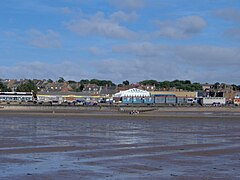
 View of Hunstanton front from the beach |
|
| Hunstanton shown within Norfolk | |
| Area | 6.07 km2 (2.34 sq mi) |
| Population | 4,229 (2011) |
| • Density | 697/km2 (1,810/sq mi) |
| OS grid reference | TF6740 |
| District | |
| Shire county | |
| Region | |
| Country | England |
| Sovereign state | United Kingdom |
| Post town | HUNSTANTON |
| Postcode district | PE36 |
| Dialling code | 01485 |
| Police | Norfolk |
| Fire | Norfolk |
| Ambulance | East of England |
| EU Parliament | East of England |
| UK Parliament | |
Hunstanton (local ![]() i/ˈhʌnstən/ HUN-stən) is a seaside town in Norfolk, England, with a population of 4,229 at the 2011 Census, which was a fall from 4,961 in 2001.) It faces west across The Wash, making it one of the few places on the East Coast where the sun can be seen setting over the sea.
i/ˈhʌnstən/ HUN-stən) is a seaside town in Norfolk, England, with a population of 4,229 at the 2011 Census, which was a fall from 4,961 in 2001.) It faces west across The Wash, making it one of the few places on the East Coast where the sun can be seen setting over the sea.
An electoral ward in the same name exists, belonging to the Borough Council of King's Lynn and West Norfolk. The population of this ward at the 2011 Census was 5,420. Hunstanton has a mayor and a 17-member Town Council that meets twice a month.
The coastal cliffs include the type section of the Hunstanton Formation of lower reddish limestone which was laid down during the Lower Cretaceous. This is topped by a white chalk layer from the Upper Cretaceous epoch.
...
Wikipedia

