
Irish Sea
| Irish Sea | |
|---|---|

Satellite image
|
|
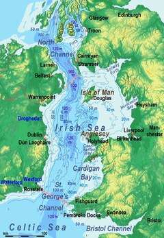
Bathymetry, limits and ports:
◘ = ferry port / ◘ = freight port only |
|
| Location | between Great Britain and Ireland |
| Coordinates | 53°N 5°W / 53°N 5°WCoordinates: 53°N 5°W / 53°N 5°W |
| Type | Sea |
| Basin countries | United Kingdom; Republic of Ireland; Isle of Man |
| Surface area | 46,007 km2 (17,763 sq mi) |
| Water volume | 2,800 km3 (2.3×10⁹ acre·ft) |
| Islands | Anglesey and Holy Island, Isle of Man and Calf of Man, Bardsey Island, Walney, Lambay, Ireland's Eye |
| Settlements | (see below) |
The Irish Sea (Irish: Muir Éireann / An Mhuir Mheann,Manx: Y Keayn Yernagh,Scots: Erse Sea, Scottish Gaelic: Muir Èireann,Ulster-Scots: Airish Sea, Welsh: Môr Iwerddon), separates the islands of Ireland and Great Britain. It is connected to the Celtic Sea in the south by St George's Channel, and to the Inner Seas off the West Coast of Scotland in the north by the North Channel. Anglesey is the largest island within the Irish Sea, followed by the Isle of Man. The sea is occasionally, but rarely, referred to as the Manx Sea (Irish: Muir Meann,Manx: Mooir Vannin, Scottish Gaelic: Muir Mhanainn).
The sea is of significant economic importance to regional trade, shipping and transport, fishing, and power generation in the form of wind power and nuclear power plants. Annual traffic between Great Britain and Ireland amounts to over 12 million passengers and 17 million tonnes (17,000,000 long tons; 19,000,000 short tons) of traded goods.
The Irish Sea has undergone a series of dramatic changes over the last 20,000 years as the last glacial period ended and was replaced by warmer conditions. At the height of the glaciation the central part of the modern sea was probably a long freshwater lake. As the ice retreated 10,000 years ago the lake reconnected to the sea, becoming brackish and then fully saline once again.
...
Wikipedia