Kearney, Nebraska
| Kearney, Nebraska | |
|---|---|
| City | |

The Great Platte River Road Archway Monument, which spans Interstate 80
|
|
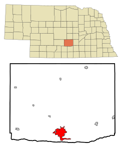
 Location of Kearney within Nebraska and Buffalo County |
|
| Coordinates: 40°42′3″N 99°4′52″W / 40.70083°N 99.08111°WCoordinates: 40°42′3″N 99°4′52″W / 40.70083°N 99.08111°W | |
| Country | United States |
| State | Nebraska |
| County | Buffalo |
| Government | |
| • Mayor | Stanley Clouse |
| Area | |
| • Total | 13.00 sq mi (33.67 km2) |
| • Land | 12.77 sq mi (33.07 km2) |
| • Water | 0.23 sq mi (0.60 km2) |
| Elevation | 2,152 ft (656 m) |
| Population (2010) | |
| • Total | 30,787 |
| • Estimate (2012) | 31,790 |
| • Density | 2,410.9/sq mi (930.9/km2) |
| Time zone | Central (CST) (UTC-6) |
| • Summer (DST) | CDT (UTC-5) |
| ZIP codes | 68845, 68847, 68848 (P.O. Box), 68849 UNK |
| Area code(s) | 308 |
| FIPS code | 31-25055 |
| GNIS feature ID | 0830442 |
| Website | www |
Kearney /ˈkɑːrni/ is a city in and the county seat of Buffalo County, Nebraska, United States. The population was 30,787 at the 2010 census. It is home to the University of Nebraska at Kearney. The westward push of the railroad as the Civil War ended gave birth to the community.
Kearney is located at 40°42′3″N 99°4′52″W / 40.70083°N 99.08111°W (40.700731, -99.081150). Strategically located on I-80 with convenient access to major markets like Omaha-Lincoln, Denver, Kansas City, Des Moines, Wichita and Cheyenne, Kearney is at the center of a 7-state region and 20 million people. According to the United States Census Bureau, the city has a total area of 13.00 square miles (33.67 km2), of which, 12.77 square miles (33.07 km2) is land and 0.23 square miles (0.60 km2) is water.
Kearney is the principal city of the Kearney, Nebraska Micropolitan Statistical Area, which consists of Buffalo and Kearney counties.
As of the census of 2010, there were 30,787 people, 12,201 households, and 7,015 families residing in the city. The population density was 2,410.9 inhabitants per square mile (930.9/km2). There were 12,738 housing units at an average density of 997.5 per square mile (385.1/km2). The racial makeup of the city was 92.3% White, 1.0% African American, 0.3% Native American, 1.8% Asian, 3.1% from other races, and 1.4% from two or more races. Hispanic or Latino of any race were 7.3% of the population.
...
Wikipedia
