Kootenay Lake
| Kootenay Lake | |
|---|---|

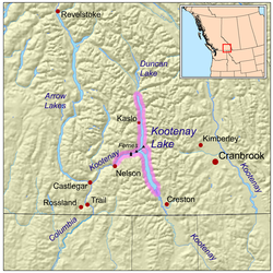
Map of Kootenay Lake, British Columbia
|
|
| Location | Kootenay region, British Columbia |
| Coordinates | 49°38′N 116°55′W / 49.633°N 116.917°WCoordinates: 49°38′N 116°55′W / 49.633°N 116.917°W |
| Primary inflows | Kootenay River |
| Primary outflows | Kootenay River |
| Basin countries | Canada |
| Max. length | 104 km (65 mi) |
| Max. width | 5 km (3.1 mi) |
| Average depth | west arm 10 m (33 ft), main lake 45 m (148 ft) |
| Max. depth | 150 m (490 ft) |
| Residence time | avg. 1.5 years |
| Surface elevation | 532 m (1,745 ft) |
| Settlements | Nelson, British Columbia |
Kootenay Lake is a lake located in British Columbia, Canada and is part of the Kootenay River. The lake has been raised by the Corra Linn Dam and has a dike system at the southern end, which, along with industry in the 1950s-70s, has changed the ecosystem in and around the water. Kootenay Lake has a year-round toll-free ferry that crosses between Kootenay Bay and Balfour, and is a popular summer tourist destination.
Kootenay Lake is a long, narrow and deep fjord-like lake located between the Selkirk and Purcell mountain ranges in the Kootenay region of British Columbia. It is one of the largest lakes in British Columbia, at 104 km in length and 3–5 km in width. It is, in part, a widening of the Kootenay River, which in turn drains into the Columbia River system at Castlegar, British Columbia.
Although oriented primarily in a north-south configuration, a western arm positioned roughly halfway up the length of the lake stretches 35 km to the City of Nelson. The lake is 532m above sea level, with the adjacent mountains rising up to a maximum of approximately 2700m. The average residence for water in the lake is 1.5 years, although the west arm has a much faster rate of water replacement; about 3–4 days.
Kootenay Lake was formed through river erosion and, later, glaciation. The erosion began during the late Cretaceous until ice filled the resulting valley in the . When the valley was filled with ice, glaciers from the mountains (the Selkirks and Purcells) fed the valley's ice mass. The glacier that occupied what is now the west arm of Kootenay Lake flowed into the Kootenay ice mass. As the ice melted from this glacier, drainage flowed over an area near what is now Nelson, causing the west arm of the lake to drain toward the west. A large moraine formed near what is now the large bend in the Kootenay River near Libby, Montana. As ice melted, a lake formed behind the moraine and drained southward over top of it. The southerly drainage over the moraine eventually stopped and the Kootenay River began to follow its present course.
...
Wikipedia
