La Carlota, Negros Occidental
| La Carlota | ||
|---|---|---|
| Component City | ||
| City of La Carlota | ||

Our Lady of Peace and Good Voyage Catholic Church
|
||
|
||
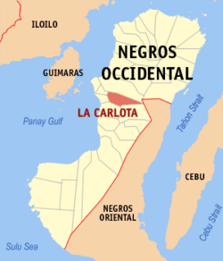
 Map of Negros Occidental with La Carlota City highlighted |
||
| Location within the Philippines | ||
| Coordinates: 10°25′N 122°55′E / 10.417°N 122.917°ECoordinates: 10°25′N 122°55′E / 10.417°N 122.917°E | ||
| Country |
|
|
| Region | Negros Island Region (NIR/Region XVIII) | |
| Province | Negros Occidental | |
| District | 4th district of Negros Occidental | |
| Founded | October 15, 1869 | |
| Cityhood | June 19, 1965 | |
| Barangays | 14 | |
| Government | ||
| • Mayor | Juliet Ferrer | |
| Area | ||
| • Total | 137.29 km2 (53.01 sq mi) | |
| Population (2015) | ||
| • Total | 64,469 | |
| • Density | 470/km2 (1,200/sq mi) | |
| Time zone | PST (UTC+8) | |
| ZIP Code | 6130 | |
| IDD : area code | 34 | |
| Income class | 4th class | |
| Website | www |
|
La Carlota, officially City of La Carlota, is a fourth-class component city in the province of Negros Occidental in Negros Island Region, Philippines. With a population of only 64,469 as of 2015, it is the least populous city in the province. Until two years after its foundation in 1871, it was known as Simancas, a barrio under the jurisdiction of the neighboring town of San Enrique, which was led by a Spaniard who was married to a woman named Carlota.
Legend has it that she was well-loved by the natives for her social works so that they named their settlement after her when it was created as a municipality near the end of the Spanish colonial era in the Philippines. In line with the Spanish practice of adding an article before a proper noun, “La Carlota” became its official name. On June 19, 1965, by virtue of Republic Act No. 4585, La Carlota was granted a city charter, becoming one of the two landlocked cities in the island region, the other being neighbouring Canlaon City in Negros Oriental.
In 2011, the Department of the Interior and Local Government (DILG) awarded the city with a "seal of good housekeeping" for its efforts in advancing accountability and transparency in local governance. In the same year, it was also named as one of the top-performing local government units in the Philippines, ranking eighth in the component cities category. On December 29, 2011, the city was nominated for excellence in local governance, an honor given by the provincial government under its Pagpasidungog Awards .
Throughout much of its early history, agriculture was the main source of livelihood for the native settlers of Simancas. The original inhabitants grew rice for their own consumption and latter ones cultivated tobacco for export during the Spanish colonial era. Early settlers were drawn to Candaguit River from where Simancas expanded. In 1856 historians began mentioning the village of Mampunay in their accounts of the settlement's history. The local parish priest of San Enrique at the time designated Simancas as a barrio.
Prior to the establishment of the permanent Spanish settlement in the Philippines in 1565, Simancas was led by Mangkas, a negrito warrior. He lived around the area of what is today known as Canman-ug Creek. People looked up to him for his bravery in warding off hostile forces and for keeping the peace. Legend says that because the people revered him, they named their children after him. With many inhabitants named Mangkas, the settlement eventually became known as Simancas.
...
Wikipedia


