Lebanon, Missouri
| Lebanon, Missouri | |
|---|---|
| City | |
| Motto: "Friendly People. Friendly Place." | |
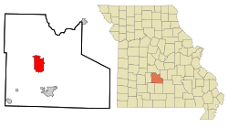
 Location of Lebanon, Missouri |
|
| Coordinates: 37°40′42″N 92°39′42″W / 37.67833°N 92.66167°WCoordinates: 37°40′42″N 92°39′42″W / 37.67833°N 92.66167°W | |
| Country | United States |
| State | Missouri |
| County | Laclede |
| Incorporated | 1877 |
| Government | |
| • Mayor | Josh Ray |
| Area | |
| • Total | 14.72 sq mi (38.12 km2) |
| • Land | 14.63 sq mi (37.89 km2) |
| • Water | 0.09 sq mi (0.23 km2) |
| Elevation | 1,265 ft (386 m) |
| Population (2010) | |
| • Total | 14,474 |
| • Estimate (2012) | 14,543 |
| • Density | 989.3/sq mi (382.0/km2) |
| Time zone | Central (CST) (UTC-6) |
| • Summer (DST) | CDT (UTC-5) |
| ZIP code | 65536 |
| Area code(s) | 417 |
| FIPS code | 29-41168 |
| GNIS feature ID | 0720871 |
| Website | www |
Lebanon is a city in Laclede County, Missouri, United States. The population was 14,474 at the 2010 census. It is the county seat of Laclede County. The Lebanon Micropolitan Statistical Area consists of Laclede County.
Lebanon was founded in 1849. The community was named after Lebanon, Tennessee, the native home of a share of the first settlers. Lebanon also had many motels, for travelers along Route 66 to stay in. After the death of Route 66, Lebanon didn't die, but was only wounded.
The Ralph E. Burley House, Joe Knight Building, Laclede County Jail, Ploger-Moneymaker Place, and Wallace House are listed on the National Register of Historic Places.
Lebanon is located at 37°40′42″N 92°39′42″W / 37.67833°N 92.66167°W (37.678203, -92.661694). According to the United States Census Bureau, the city has a total area of 14.72 square miles (38.12 km2), of which, 14.63 square miles (37.89 km2) is land and 0.09 square miles (0.23 km2) is water.
As of the census of 2010, there were 14,474 people, 5,980 households, and 3,745 families residing in the city. The population density was 989.3 inhabitants per square mile (382.0/km2). There were 6,728 housing units at an average density of 459.9 per square mile (177.6/km2). The racial makeup of the city was 94.1% White, 1.3% African American, 0.6% Native American, 0.7% Asian, 0.1% Pacific Islander, 0.7% from other races, and 2.4% from two or more races. Hispanic or Latino of any race were 2.6% of the population.
...
Wikipedia
