Mount Hamilton (California)
| Mount Hamilton | |
|---|---|
| Sierra de Santa Isabel | |

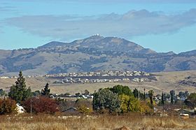
Lick Observatory is visible atop Mount Hamilton; hillsides show typical summer golden (dry) vegetation
|
|
| Highest point | |
| Elevation | 4,265 ft (1,300 m) NAVD 88 |
| Prominence | 93 ft (30 m) |
| Coordinates | 37°20′30.2″N 121°38′34.2″W / 37.341722°N 121.642833°WCoordinates: 37°20′30.2″N 121°38′34.2″W / 37.341722°N 121.642833°W |
| Geography | |
| Location | Santa Clara County, California, U.S. |
| Parent range | Diablo Range |
| Topo map | USGS Lick Observatory |
| Geology | |
| Age of rock | Upper Cretaceous |
| Climbing | |
| First ascent | 1861 |
| Easiest route | Hike |
Mount Hamilton is a mountain in California's Diablo Range, in Santa Clara County, California. Mount Hamilton, at 4,265 feet (1,300 m) is a mountain overlooking Santa Clara Valley and is the site of Lick Observatory, the first permanently occupied mountain-topobservatory. The asteroid 452 Hamiltonia, discovered in 1899, is named after the mountain. Golden eagle nesting sites are found on the slopes of Mount Hamilton. On clear days, the Santa Cruz Mountains, Monterey Bay, the Monterey Peninsula, and even Yosemite National Park are visible from the summit of the mountain.
On August 26, 1861, while working for Josiah D. Whitney on the first California Geological Survey, William H. Brewer invited local San Jose preacher (and Brewer's personal friend) Laurentine Hamilton to join his company on a trek to a nearby summit. Nearing completion of their journey, Hamilton, in good humor, bounded for the summit ahead of the rest of the men and claimed his stake. In fact, Brewer suggested the mountain be named after Hamilton only after Whitney declined to have the mountain named after him (a different mountain was later named Mount Whitney).
...
Wikipedia

