Mount Iwate
| Mount Iwate | |
|---|---|
| 岩手山 | |

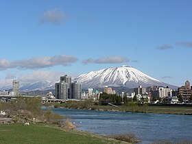
Mount Iwate from the city of Morioka
|
|
| Highest point | |
| Elevation | 2,038 m (6,686 ft) |
| Prominence | 1,745 m (5,725 ft) |
| Listing |
List of mountains and hills of Japan by height List of volcanoes in Japan Ultra |
| Coordinates | 39°51′12″N 141°00′03″E / 39.85333°N 141.00083°ECoordinates: 39°51′12″N 141°00′03″E / 39.85333°N 141.00083°E |
| Geography | |
| Location | Iwate Prefecture, Japan |
| Geology | |
| Mountain type | Stratovolcano complex |
| Last eruption | July 1919 |
Mount Iwate (岩手山 Iwate-san?) is a stratovolcano complex located northwest of the city of Morioka in western Iwate Prefecture, Tohoku, Japan. The mountain is listed as one of the 100 Famous Japanese Mountains in a book composed in 1964 by mountaineer/author Kyūya Fukada.
Mount Iwate consists of a younger eastern symmetrical stratovolcano (Higashi-Iwate, "East Iwate") overlapping an older western stratovolcano (Nishi-Iwate, "West Iwate") which has collapsed to form a caldera.
The oval-shaped, 1.8 x 3 km caldera has a central cone containing a 0.5 km wide crater, partially filled by a crater lake.
...
Wikipedia

