Mthatha Airport
| Mthatha Airport | |||||||||||
|---|---|---|---|---|---|---|---|---|---|---|---|
| Summary | |||||||||||
| Airport type | Public | ||||||||||
| Operator | Provincial Government | ||||||||||
| Serves | Mthatha, Eastern Cape, South Africa | ||||||||||
| Elevation AMSL | 2,429 ft / 740 m | ||||||||||
| Coordinates | 31°32′47″S 028°40′31″E / 31.54639°S 28.67528°ECoordinates: 31°32′47″S 028°40′31″E / 31.54639°S 28.67528°E | ||||||||||
| Map | |||||||||||
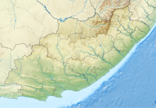
| Location of the airport in the Eastern Cape | |||||||||||
| Runways | |||||||||||
|
|||||||||||
Mthatha Airport (IATA: UTT, ICAO: FAUT) is an airport serving Mthatha (formerly Umtata), a town in the Eastern Cape province of South Africa. The airport was previously named K. D. Matanzima Airport after Kaiser Matanzima, a president of the former Transkei.
The airport resides at an elevation of 2,429 feet (740 m) above mean sea level. It has one asphalt paved runway designated 14/32 which measures 2,600 by 45 metres (8,530 ft × 148 ft). Runway 14/32 was expanded from its previous size of 2,000 by 23 metres (6,562 ft × 75 ft) in 2013; previously there was also a grass runway designated 09/27 which measured 1,500 by 30 metres (4,921 ft × 98 ft).
On 16 May 2012, the Cabinet of South Africa approved a decision to hand over the airport for use by the South African National Defence Force (SANDF). On 21 May 2012, the airport was formally handed over to Lindiwe Sisulu, then Minister of Defence, by Noxolo Kiviet, then Premier of the Eastern Cape. Sisulu said that the airport would be used for border security operations, and the SANDF would contribute towards the development of the airport thus building regional transport infrastructure.
...
Wikipedia

