Mueang Narathiwat District
|
Mueang Narathiwat เมืองนราธิวาส |
|
|---|---|
| Amphoe | |
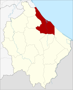
 Amphoe location in Narathiwat Province |
|
| Coordinates: 6°25′34″N 101°49′23″E / 6.42611°N 101.82306°ECoordinates: 6°25′34″N 101°49′23″E / 6.42611°N 101.82306°E | |
| Country |
|
| Province | Narathiwat |
| Seat | Bang Nak |
| Area | |
| • Total | 305.115 km2 (117.806 sq mi) |
| Population (2005) | |
| • Total | 108,644 |
| • Density | 356.1/km2 (922/sq mi) |
| Time zone | THA (UTC+7) |
| Postal code | 96000 |
| Geocode | 9601 |
Mueang Narathiwat (Thai: เมืองนราธิวาส) is the capital district (amphoe mueang) of Narathiwat Province, southern Thailand.
The area of Mueang Narathiwat was originally a village named Menara (เมอนารา or เมอนารอ), under Mueang Sai Buri. Later it was upgraded to a Tambon and changed to be controlled by Mueang Ra-ngae. Tambon Manalo grew bigger and bigger, so the government moved the city hall from Tambon Tanyong Mat to Manalo. Then they upgraded Tambon Manalo to Mueang Bang Nara. King Vajiravudh (Rama VI) renamed the city to Narathiwat in 1915, however in 1917 the district was renamed from Mueang to the old name Bang Nara. In 1938 the district name was changed to Mueang Narathiwat district as the province name.
Neighboring districts are (from the southeast clockwise) Tak Bai, Cho-airong, Ra-ngae, Yi-ngo, Bacho of Narathiwat Province, Mai Kaen of Pattani Province and the Gulf of Thailand.
The important water resource is the Bang Nara River.
The Ao Manao-Khao Tanyong National Park is located within the district.
The district is subdivided into 7 subdistricts (tambon), which are further subdivided into 57 villages (muban). The town (thesaban mueang) Narathiwat covers parts of tambon Bang Nak. The 6 remaining tambon are each led by a Tambon administrative organization (TAO).
...
Wikipedia
