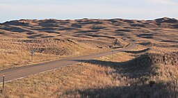
Nebraska Sand Hills mixed grasslands
| Sandhills | |
| Region | |
|
Sandhills in Hooker County, near sunset in October
|
|
| Country | |
|---|---|
| State | |
| Part of | Great Plains, High Plains |
| Rivers | Niobrara River, Snake River, North Loup River, Middle Loup River, Dismal River |
| Area | 19,600 sq mi (50,764 km2) |
|
The Sandhills covers portions of northern and western Nebraska.
|
|
| Designated | 1984 |
The Sandhills, often written Sand Hills, is a region of mixed-grass prairie on grass-stabilized sand dunes in north-central Nebraska, covering just over one quarter of the state. The dunes were designated a National Natural Landmark in 1984.
The boundaries of the Sandhills are variously defined by different organizations. Depending on the definition, the region's area can be as small as 19,600 mi2 (50,760 km2) or as large as 23,600 mi2 (61,100 km2).
Dunes in the Sandhills may exceed 330 ft (100 m) in height. The average elevation of the region gradually increases from about 1,800 ft (550 m) in the east to about 3,600 ft (1,100 m) in the west.
The Sandhills sit atop the massive Ogallala Aquifer; thus both temporary and permanent shallow lakes are common in low-lying valleys between the grass-stabilized dunes prevalent in the Sandhills. The eastern and central sections of the region are drained by tributaries of the Loup River and the Niobrara River, while the western section is largely composed of small interior drainage basins.
The World Wide Fund for Nature (WWF) designated the Sandhills as an ecoregion, distinct from other grasslands of the Great Plains. According to their assessment, as much as 85% of the ecoregion is intact natural habitat, the highest level in the Great Plains. This is chiefly due to the lack of crop production: most of the Sandhills land has never been plowed.
Paleoclimate proxy data and computer simulations reveal that the Nebraska Sandhills likely had active sand dunes as recently as the Medieval Warm Period, when temperatures in the North Atlantic region were about 1°C (1.8°F) warmer than the current climate. Much of the area was a scrub desert, with desert-like conditions extending to several other states. Current global warming may make the grassland climate more unstable, giving way to desert given more fires, mild drought and erosion; UCAR simulations based on evapotranspiration support a Palmer Drought Index lower than -15, many times more severe than Texas during the Dust Bowl.
...
Wikipedia


