North American Ice Storm of 1998

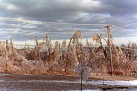
An example of the damage to trees
|
|
| Type |
Extratropical cyclone Ice storm Winter storm |
|---|---|
| Formed | January 4, 1998 |
| Dissipated | January 10, 1998 |
| Lowest pressure | Unknown |
| Maximum snowfall or ice accretion | around 5 inches (130 mm) (freezing rain) |
| Damage | $5–7 billion (2005 US$) |
| Power outages | 4 million at peak |
| Casualties | 35 deaths total, 28 in Canada 945 injuries |
| Areas affected | Ice in Atlantic Canada, southern Quebec, Eastern Ontario, northern New York and northern New England; rain/flooding in the Appalachians |
The North American Ice Storm of 1998 (also known as Great Ice Storm of 1998) was a massive combination of five smaller successive ice storms in January 1998 that struck a relatively narrow swath of land from eastern Ontario to southern Quebec and Nova Scotia in Canada, and bordering areas from northern New York to central Maine in the United States. It caused massive damage to trees and electrical infrastructure all over the area, leading to widespread long-term power outages. Millions were left in the dark for periods varying from days to several weeks, and in some instances, months. It led to 35 fatalities, a shutdown of activities in large cities like Montreal and Ottawa, and an unprecedented effort in reconstruction of the power grid. The ice storm led to the largest deployment of Canadian military personnel since the Korean War, with over 16,000 Canadian Forces personnel deployed, 12,000 in Quebec and 4,000 in Ontario at the height of the crisis.
Freezing rain is common in Canada and New England, generally occurring at the narrow boundary between cold air from the east and north and moist air from the south. Typically, a warm air mass will travel northward along the Mississippi Valley and overrun a shallow layer of cold air trapped at the surface. Such a favorable cold air damming happens with an east to northeasterly flow in the St. Lawrence (the predominant wind direction in the St. Lawrence Valley is usually either northeast or southwest) and the Ottawa Valley and along the axis of the Appalachian Mountains.
Snow is produced at upper levels in such a winter storm system, but it eventually melts into rain as it falls through a warm air layer of above freezing temperature (of at least 1,200 feet (370 m) in depth) associated with the overrunning. The rain passes through colder air near the surface and supercools. When that rain touches the ground or any other cold surface in the cold air below, the droplets freeze on contact, creating accumulations of ice. If the cold air layer is too thick, the droplets refreeze before hitting the ground and form ice pellets, which are usually less hazardous.
...
Wikipedia
