Penrhyndeudraeth
| Penrhyndeudraeth | |
|---|---|
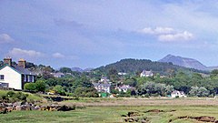
 Penrhyndeudraeth from River Dwyryd |
|
| Penrhyndeudraeth shown within Gwynedd | |
| Population | 2,150 (2011) |
| OS grid reference | SH611388 |
| Community |
|
| Principal area | |
| Country | Wales |
| Sovereign state | United Kingdom |
| Post town | PENRHYNDEUDRAETH |
| Postcode district | LL48 |
| Dialling code | 01766 |
| Police | North Wales |
| Fire | North Wales |
| Ambulance | Welsh |
| EU Parliament | Wales |
| UK Parliament | |
| Welsh Assembly | |
Penrhyndeudraeth (English: "peninsula with two beaches") is a small town in the Welsh county of Gwynedd. The town is close to the mouth of the River Dwyryd on the A487 nearly 3 miles (4.8 km) east of Porthmadog, and had a population of 2,150 at the 2011 census, increased from 2,031 in 2001.
An older settlement of a few cottages at Upper Penrhyn was originally called Cefn Coch ('Red Ridge') and that name is perpetuated by the Penrhyndeudraeth primary school, which is known as Ysgol Cefn Coch; but the town proper is comparatively modern. The ground on which it stands was a malarial swamp encircling a huge stagnant pool. The present town owes its existence as a commercial centre to a local landowner, David Williams of Castell Deudraeth near Minffordd, who in the mid-19th century drained the swamp and dried the pool and constructed many streets. Adopting a scheme of town planning evolved by the builder of Tremadog and his Italian craftsmen, Williams gave Penrhyndeudraeth broad streets and wide open spaces. The main square is a road junction with choice of four roads - one leading to the station, one to Porthmadog, one to Maentwrog and the other to Llanfrothen and the Pass of Aberglaslyn.
The lower half of Penrhyndeudraeth used to be a lake, which was then drained to create the area where the village's High Street is today. The names of terraces in Penrhyndeudraeth, such as Glanllyn ("lakeside") and Penllyn ("end of the lake"), refer to a time when the site was underwater. There is also an area named Penlan ('the end of the tide'), which may point to the reason why the lower half of Penrhyndeudraeth is flat. It is believed that the lower half of Penrhyndeudraeth was founded on a spot behind the Royal Oak pub where the old Pierce & Sons garage is located.
Prior to the many 19th century land reclamation projects (including The Cob at Porthmadog) and the building of the Ffestiniog Railway, both of which spurred economic growth, the few local inhabitants relied on agriculture and small-scale copper mining. Some men worked boats on the River Dwyryd, carrying slate from Maentwrog to the sea for export. Local women at that time gathered cockles in the estuary for sale in local markets. Penrhyndeudraeth is still known locally, especially by the people of Blaenau Ffestiniog and Porthmadog, as Penrhyn Cocos (or "Cockletown" in English).
...
Wikipedia

